
Adm. region Mittelfranken Vehicle registration WUG | Time zone CET (UTC+1) Website landkreis-wug.de | |
 | ||
Points of interest Destinations | ||
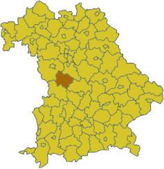
Weißenburg-Gunzenhausen is a Kreis (district) in the west of Bavaria, Germany with a population of 95,000. Neighbouring districts are (from the north clockwise) Ansbach, Roth, Eichstätt and Donau-Ries. It is located in the south of Middle Franconia, 50 kilometres south of Nuremberg. Largest city and the administrative center is Weißenburg in Bayern.
Contents
Map of Wei%C3%9Fenburg-Gunzenhausen, Germany
Geography
The district is located on the Hahnenkamm and on the Franconian Alb in the North of the Altmühltal. In the north there are several lakes of the Franconian Lake District. The highest point of the district is the Dürrenberg. The Altmühl flows through the district. From here comes the Solnhofen limestone. Among its nature reserves are the Brombachmoor.
History
The district was formed in 1972 by a merger of the districts of Gunzenhausen, Weißenburg, and the previously independent urban district of Weißenburg.