
Airport type Public Elevation AMSL 163 ft / 50 m 4,501 1,372 Elevation 50 m | 2/20 4,501 Code WVI Phone +1 831-768-3575 | |
 | ||
Address 100 Aviation Way, Watsonville, CA 95076, USA | ||
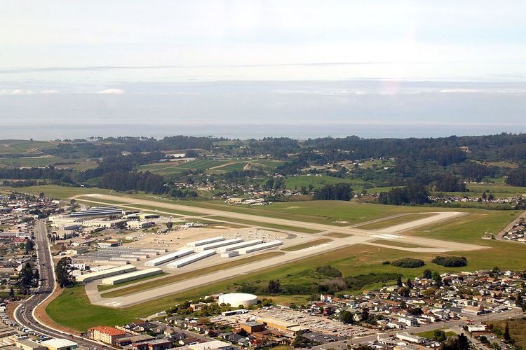
Watsonville Municipal Airport (IATA: WVI, ICAO: KWVI, FAA LID: WVI) is a public airport located three miles (5 km) northwest of the central business district (CBD) of Watsonville, a city in Santa Cruz County, California, USA. The airport covers 330 acres (134 ha) and has two runways. The largest aircraft to ever land at Watsonville were 05-5141 and 05-5143, C-17 Globemaster IIIs from March ARB, CA.
Contents
Watsonville municipal airport
Facilities
The Watsonville airport's longest runway is 02-20 and its dimensions are 4501' x 149'. The crosswind runway, 09-27, 3998' x 98', is used when winds favor it and when the fog is moving across the field from the Monterey Bay.
The airport is uncontrolled, and the CTAF is 122.8 MHz, and the ASOS can be received on 132.275 MHz or by calling 831-724-8794.
History
The Navy took over in July, 1943, purchased an additional 35 acres, built support buildings and the concrete ramp. On October 23, 1943, the airport was commissioned as Naval Air Auxiliary Station Watsonville (NAAS Watsonville) and served as a satellite to Naval Air Station (NAS) Alameda. As the World War II ended, so did operations at NAAS Watsonville, on Nov. 1, 1945 it was closed and placed on caretaker status.
Instrument Approaches
The airport has three approaches, making it a popular instrument training area.
Instrument pilots have been advised that Watsonville is occasionally surrounded by non-IFR traffic that (illegally) climbs/descends to low stratus layer. ATC usually calls them out, but they can not always see them. There are frequent traffic calls to CTAF even when IMC prevails become important.