
Country United States Time zone Central (CST) (UTC-6) Zip code 56096 Mayor Stephen Mihalik | Elevation 1,014 ft (309 m) Area code(s) 507 Population 1,864 (2013) | |
 | ||
Weather 11°C, Wind N at 5 km/h, 85% Humidity | ||
Meet shannon kuball a dairy farmer from waterville minnesota
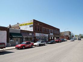
Waterville is a city in Le Sueur County, Minnesota, United States. The population was 1,868 at the 2010 census. It is close to Sakatah Lake State Park on the Cannon River.
Contents
- Meet shannon kuball a dairy farmer from waterville minnesota
- Map of Waterville MN 56096 USA
- Waterville minnesota fire at historic building
- History
- Geography
- 2010 census
- 2000 census
- Famous residents
- References
Map of Waterville, MN 56096, USA
Waterville has a yearly celebration called "Bullhead Days" it is held in early June and the residents of the town get together for food, fun a parade, carnival and fireworks.
Waterville minnesota fire at historic building
History
Waterville was platted in 1856 by nine New England natives. The name "Waterville" comes from, Waterville, Maine, E.I. Wright's, a member of the group, hometown. It is also mixed with the fact that it is positioned between Lake Tetonka and Lake Sakatah. A post office has been in operation at Waterville since 1856. Waterville was incorporated as a city in 1898.
Geography
According to the United States Census Bureau, the city has a total area of 2.34 square miles (6.06 km2), of which 1.70 square miles (4.40 km2) is land and 0.64 square miles (1.66 km2) is water.
Minnesota State Highways 13 and 60 are two of the main routes in the city.
2010 census
As of the census of 2010, there were 1,868 people, 785 households, and 486 families residing in the city. The population density was 1,098.8 inhabitants per square mile (424.2/km2). There were 963 housing units at an average density of 566.5 per square mile (218.7/km2). The racial makeup of the city was 96.9% White, 0.4% African American, 1.0% Native American, 0.3% Asian, 0.2% from other races, and 1.2% from two or more races. Hispanic or Latino of any race were 1.8% of the population.
There were 785 households of which 29.2% had children under the age of 18 living with them, 45.0% were married couples living together, 10.7% had a female householder with no husband present, 6.2% had a male householder with no wife present, and 38.1% were non-families. 33.1% of all households were made up of individuals and 14.4% had someone living alone who was 65 years of age or older. The average household size was 2.28 and the average family size was 2.87.
The median age in the city was 42.4 years. 22.7% of residents were under the age of 18; 7.2% were between the ages of 18 and 24; 23.1% were from 25 to 44; 26.9% were from 45 to 64; and 19.9% were 65 years of age or older. The gender makeup of the city was 48.1% male and 51.9% female.
2000 census
As of the census of 2000, there were 1,833 people, 756 households, and 501 families residing in the city. The population density was 1,088.8 people per square mile (421.3/km²). There were 864 housing units at an average density of 513.2 per square mile (198.6/km²). The racial makeup of the city was 97.60% White, 0.11% African American, 0.87% Native American, 0.27% Asian, 0.05% Pacific Islander, and 1.09% from two or more races. Hispanic or Latino of any race were 0.33% of the population.
There were 756 households out of which 28.4% had children under the age of 18 living with them, 52.4% were married couples living together, 9.3% had a female householder with no husband present, and 33.7% were non-families. 28.8% of all households were made up of individuals and 13.8% had someone living alone who was 65 years of age or older. The average household size was 2.32 and the average family size was 2.83.
In the city, the population was spread out with 22.3% under the age of 18, 7.0% from 18 to 24, 25.6% from 25 to 44, 24.4% from 45 to 64, and 20.7% who were 65 years of age or older. The median age was 42 years. For every 100 females there were 93.2 males. For every 100 females age 18 and over, there were 88.7 males.
The median income for a household in the city was $35,950, and the median income for a family was $45,536. Males had a median income of $32,361 versus $24,327 for females. The per capita income for the city was $17,958. About 6.6% of families and 10.6% of the population were below the poverty line, including 9.8% of those under age 18 and 11.4% of those age 65 or over.