
 | ||
Water content or moisture content is the quantity of water contained in a material, such as soil (called soil moisture), rock, ceramics, crops, or wood. Water content is used in a wide range of scientific and technical areas, and is expressed as a ratio, which can range from 0 (completely dry) to the value of the materials' porosity at saturation. It can be given on a volumetric or mass (gravimetric) basis.
Contents
Definitions
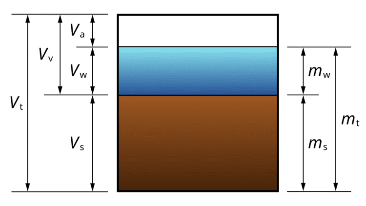
Volumetric water content, θ, is defined mathematically as:
where
Gravimetric water content is expressed by mass (weight) as follows:
where
except for woodworking, geotechnical and soil science applications where oven-dried material is used instead:
To convert gravimetric water content to volumetric water content, multiply the gravimetric water content by the bulk specific gravity
Derived quantities
In soil mechanics and petroleum engineering the water saturation or degree of saturation,
where
The normalized water content,
where
Direct methods
Water content can be directly measured using a known volume of the material, and a drying oven. Volumetric water content, θ, is calculated via the volume of water
where
For materials that change in volume with water content, such as coal, the water content, u, is expressed in terms of the mass of water per unit mass of the moist specimen:
However, geotechnics requires the moisture content to be expressed with respect to the sample's dry weight (often as a percentage, i.e. % moisture content = u×100%)
For wood, the convention is to report moisture content on oven-dry basis (i.e. generally drying sample in an oven set at 105 deg Celsius for 24 hours). In wood drying, this is an important concept.
Laboratory methods
Other methods that determine water content of a sample include chemical titrations (for example the Karl Fischer titration), determining mass loss on heating (perhaps in the presence of an inert gas), or after freeze drying. In the food industry the Dean-Stark method is also commonly used.
From the Annual Book of ASTM (American Society for Testing and Materials) Standards, the total evaporable moisture content in Aggregate (C 566) can be calculated with the formula:
where
Geophysical methods
There are several geophysical methods available that can approximate in situ soil water content. These methods include: time-domain reflectometry (TDR), neutron probe, frequency domain sensor, capacitance probe, amplitude domain reflectometry, electrical resistivity tomography, ground penetrating radar (GPR), and others that are sensitive to the physical properties of water . Geophysical sensors are often used to monitor soil moisture continuously in agricultural and scientific applications.
Satellite remote sensing method
Satellite microwave remote sensing is used to estimate soil moisture based on the large contrast between the dielectric properties of wet and dry soil. The microwave radiation is not sensitive to atmospheric variables, and can penetrate through clouds. Also, microwave signal can penetrate, to a certain extent, the vegetation canopy and retrieve information from ground surface. The data from microwave remote sensing satellite such as: WindSat, AMSR-E, RADARSAT, ERS-1-2, Metop/ASCAT are used to estimate surface soil moisture.
Classification and uses
Moisture may be present as adsorbed moisture at internal surfaces and as capillary condensed water in small pores. At low relative humidities, moisture consists mainly of adsorbed water. At higher relative humidities, liquid water becomes more and more important, depending or not depending on the pore size can also be an influence of volume. In wood-based materials, however, almost all water is adsorbed at humidities below 98% RH.
In biological applications there can also be a distinction between physisorbed water and "free" water — the physisorbed water being that closely associated with and relatively difficult to remove from a biological material. The method used to determine water content may affect whether water present in this form is accounted for. For a better indication of "free" and "bound" water, the water activity of a material should be considered.
Water molecules may also be present in materials closely associated with individual molecules, as "water of crystallization", or as water molecules which are static components of protein structure.
Earth and agricultural sciences
In soil science, hydrology and agricultural sciences, water content has an important role for groundwater recharge, agriculture, and soil chemistry. Many recent scientific research efforts have aimed toward a predictive-understanding of water content over space and time. Observations have revealed generally that spatial variance in water content tends to increase as overall wetness increases in semiarid regions, to decrease as overall wetness increases in humid regions, and to peak under intermediate wetness conditions in temperate regions .
There are four standard water contents that are routinely measured and used, which are described in the following table:
And lastly the available water content, θa, which is equivalent to:
θa ≡ θfc − θpwpwhich can range between 0.1 in gravel and 0.3 in peat.
Agriculture
When a soil becomes too dry, plant transpiration drops because the water is increasingly bound to the soil particles by suction. Below the wilting point plants are no longer able to extract water. At this point they wilt and cease transpiring altogether. Conditions where soil is too dry to maintain reliable plant growth is referred to as agricultural drought, and is a particular focus of irrigation management. Such conditions are common in arid and semi-arid environments.
Some agriculture professionals are beginning to use environmental measurements such as soil moisture to schedule irrigation. This method is referred to as smart irrigation or soil cultivation.
Groundwater
In saturated groundwater aquifers, all available pore spaces are filled with water (volumetric water content = porosity). Above a capillary fringe, pore spaces have air in them too.
Most soils have a water content less than porosity, which is the definition of unsaturated conditions, and they make up the subject of vadose zone hydrogeology. The capillary fringe of the water table is the dividing line between saturated and unsaturated conditions. Water content in the capillary fringe decreases with increasing distance above the phreatic surface.
One of the main complications which arises in studying the vadose zone, is the fact that the unsaturated hydraulic conductivity is a function of the water content of the material. As a material dries out, the connected wet pathways through the media become smaller, the hydraulic conductivity decreasing with lower water content in a very non-linear fashion.
A water retention curve is the relationship between volumetric water content and the water potential of the porous medium. It is characteristic for different types of porous medium. Due to hysteresis, different wetting and drying curves may be distinguished.