
Country United States Elevation 271 m Population 1,436 (2010) | GNIS feature ID 454024 Area 109 km² Local time Saturday 11:42 PM | |
 | ||
Weather 10°C, Wind S at 8 km/h, 47% Humidity | ||
Washington Township is one of fifteen townships in Wayne County, Indiana, United States. As of the 2010 census, its population was 1,436 and it contained 626 housing units.
Contents
- Map of Washington Township IN USA
- History
- Geography
- Cities and towns
- Unincorporated towns
- Adjacent townships
- Cemeteries
- Major highways
- References
Map of Washington Township, IN, USA
History
Washington Township was organized in 1817.
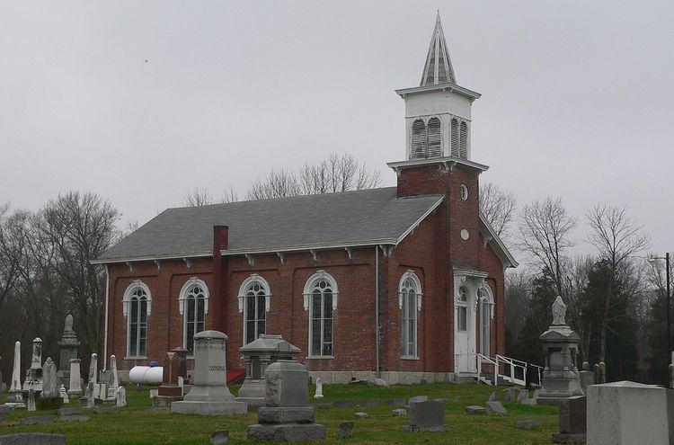
Beechwood (Isaac Kinsey House) and the Doddridge Chapel and Cemetery are listed on the National Register of Historic Places.
Geography
According to the 2010 census, the township has a total area of 42.08 square miles (109.0 km2), of which 41.6 square miles (108 km2) (or 98.86%) is land and 0.48 square miles (1.2 km2) (or 1.14%) is water. The streams of Brethren Run, Butlers Creek, Central Run, City Run, Common Run, Dry Branch, Franklin Creek, Greens Fork, Martindale Creek, Milton Drain, Shaker Run, Warm Run, Wilson Run and Woodclinch Brook run through this township.
Cities and towns
Unincorporated towns
(This list is based on USGS data and may include former settlements.)
Adjacent townships
Cemeteries
The township contains six cemeteries: Doddridge Chapel Cemetery, Franklin, Friends, South Side, United Brethren and West Side.