
Existed: 1991 – present Length 22.29 km | Counties: Whatcom Constructed 1 April 1992 | |
 | ||
County | ||
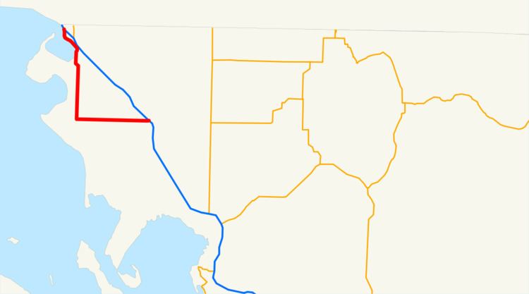
State Route 548 (SR 548) is a 13.85-mile-long (22.29 km) state highway serving Whatcom County in the U.S. state of Washington. The highway travels northwest between two interchanges with Interstate 5 (I-5) north of Ferndale and in Blaine. SR 548 in Blaine, named Peace Portal Drive, follows the route of the Pacific Highway, later U.S. Route 99 (US 99) and Primary State Highway 1 (PSH 1). US 99 was decommissioned during the 1964 highway renumbering and the highway was maintained by Whatcom County until it was designated as SR 548 in 1991.
Contents
Map of WA-548, Washington, USA
Route description
SR 548 begins north of Ferndale as Grandview Road at a diamond interchange with I-5, signed as exit 266, and travels west over California Creek into rural Whatcom County. The highway crosses a BNSF rail line and continues west towards Birch Bay, passing north of Lake Terrell and its state game refuge. SR 548 turns north onto Blaine Road at a roundabout and travels through Birch Bay before crossing Dakota Creek into Blaine. The highway crosses over the BNSF rail line and turns northwest onto Peace Portal Drive northwest of an interchange with I-5. Peace Portal Drive continues north along the rail line and Drayton Harbor into Downtown Blaine, ending at a dumbbell interchange with I-5, signed as exit 276, continuing east as D Street.
Every year, the Washington State Department of Transportation (WSDOT) conducts a series of surveys on its highways in the state to measure traffic volume. This is expressed in terms of average annual daily traffic (AADT), which is a measure of traffic volume for any average day of the year. In 2011, WSDOT calculated that between 2,100 and 9,100 vehicles per day used the highway, mostly near Birch Bay.
History
SR 548 between Birch Bay and Blaine follows the route of a wagon road built in the 1900s parallel to a Great Northern rail line. The wagon road was codified in 1913 as the northernmost segment of the Pacific Highway, which later became State Road 1 during a 1923 restructuring of the highway system. The United States Numbered Highways were created in 1926 and US 99 was assigned to the Pacific Highway, becoming concurrent with the entire highway, which was replaced by PSH 1 in 1937. PSH 1 and US 99 were replaced during the 1964 highway renumbering by I-5 and Peace Portal Drive was removed from the highway system. SR 548 was created in 1991 from Peace Portal Drive, Blaine Road, and Grandview Road between Ferndale and Blaine in the last major revision of the highway. In 2010, WSDOT improved the I-5 interchange in Blaine at a cost of $13.2 million by converting it to a dogbone interchange using two new roundabouts.
Major intersections
The entire highway is in Whatcom County.