
Existed: 1964 – present Length 56.6 km | Constructed 1964 North end SR 99 in Seattle | |
 | ||
Counties | ||
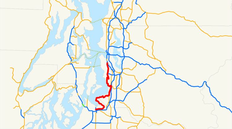
State Route 509 (SR 509) is a 35.17-mile-long (56.60 km) state highway in the U.S. state of Washington, connecting Tacoma in Pierce County to Seattle in King County. The highway travels north from Interstate 705 (I-705) in Tacoma to SR 99 south of downtown Seattle. It serves cities along the Puget Sound and west of Seattle–Tacoma International Airport in south King County, including Federal Way, Des Moines, and Burien. SR 509 is part of the National Highway System and is a limited-access highway near the Port of Tacoma and from Burien to its northern terminus in Seattle. Prior to the 1964 highway renumbering, the highway was part of Secondary State Highway 1V (SSH 1V) from Tacoma to Des Moines and SSH 1K from Des Moines to Seattle. SR 509 was re-aligned onto the Burien Freeway in 1968 and the Port of Tacoma bypass in 1997, coinciding with the opening of its interchange with I-705 and the cable-stayed 21st Street Bridge. Various proposals since 1988 have recommended building a freeway extension of SR 509 within the city of SeaTac, connecting the Burien Freeway to I-5, that remains unbuilt.
Contents
Map of WA-509, Washington, USA
Route description
SR 509 begins as South 21st Street at a single-point urban interchange with I-705 in downtown Tacoma in Pierce County, providing access to the Tacoma campus of the University of Washington and the Tacoma Link light rail line on Pacific Avenue. The highway travels east over the Thea Foss Waterway on the cable-stayed 21st Street Bridge into the Port of Tacoma as a four-lane limited-access highway, intersecting Portland Avenue in a half-diamond interchange before crossing the Puyallup River. SR 509 continues east, parallel to a City of Tacoma rail line through a partial cloverleaf interchange with Port of Tacoma Road before the divided highway ends at Taylor Way. The highway turns northwest along the Hylebos Waterway as Marine View Drive through the neighborhood of Northeast Tacoma towards Browns Point. SR 509 passes through Dash Point and its state park along the Puget Sound into King County and the city of Federal Way. The highway travels east as Dash Point Road through Federal Way past Decatur and Federal Way high schools before a junction with SR 99 west of I-5. The concurrent SR 99 and SR 509 travel north as the Pacific Highway past Highline Community College to an intersection with SR 516 in western Kent. SR 509 turns west to form a concurrency with SR 516, heading past Mount Rainier High School and into Des Moines, where SR 516 ends.
SR 509 continues north onto Marine View Drive through the city of Normandy Park and into SeaTac. The highway turns southeast onto Ambaum Boulevard and Des Moines Memorial Drive to a trumpet interchange, the southern terminus of a limited-access freeway section of SR 509. The four-lane freeway travels west of Seattle–Tacoma International Airport through a closed half-diamond interchange with South 176th Street and a partial cloverleaf interchange with South 160th Street before entering the city of Burien. SR 509 passes Highline High School before reaching a partial cloverleaf interchange with Southwest 148th Street and the western terminus of SR 518. The freeway continues north into the West Seattle neighborhood of Seattle and intersects South 128th Street in a diamond interchange and South 112th Street in a half-diamond interchange. SR 509 enters the Industrial District of Seattle and heads through an interchange with Cloverdale Street and Myers Way before ending at a partial cloverleaf interchange with SR 99 south of the First Avenue South Bridge over the Duwamish Waterway. The roadway continues north as the SR 99 divided highway toward downtown Seattle and the Alaskan Way Viaduct.
Every year, the Washington State Department of Transportation (WSDOT) conducts a series of surveys on its highways in the state to measure traffic volume. This is expressed in terms of annual average daily traffic (AADT), which is a measure of traffic volume for any average day of the year. In 2011, WSDOT calculated that the busiest section of SR 509 was the limited-access highway between Burien and its northern terminus in Seattle, serving 54,000 vehicles, while the least busiest section was within Dash Point and Dash Point State Park, serving 2,600 vehicles. SR 509 between SeaTac and Seattle is designated as part of the National Highway System, which includes roadways important to the national economy, defense, and mobility. The highway from Tacoma to Federal Way and from SeaTac to Seattle are designated as part of WSDOT's Highways of Statewide Significance, which includes highways that connect major communities in the state of Washington.
History
The present route of SR 509 from Des Moines to Seattle roughly follows a wagon road constructed in the late 1890s by King County along the Puget Sound. The highway between Federal Way and Kent was codified in 1923 as part of State Road 1 and in 1937 as Primary State Highway 1 (PSH 1). During the creation of the primary and secondary state highways in 1937, the highway between Tacoma and Federal Way was designated as SSH 1V and the highway between Des Moines and Seattle was designated as SSH 1K. SSH 1V traveled 19.54 miles (31.45 km) north from PSH 1 in Tacoma through the Port of Tacoma on the 11th Street Bridge and the Blair Bridge, opened in 1913 and 1951 respectively, to Federal Way, ending at an intersection with SSH 1K. SSH 1K traveled 12.76 miles (20.54 km) south from PSH 1 at the First Avenue South Bridge in Seattle through Burien and east through Des Moines to PSH 1 in Midway. The two highways were combined during the 1964 highway renumbering to become SR 509 and was codified into law in 1970. SR 509 was realigned onto the newly constructed north–south Burien Freeway in 1968, extending from Seattle to SeaTac. The highway was originally routed through Saltwater State Park on Marine View Drive until 1991, when SR 509 was moved to two concurrencies with SR 99 in Federal Way and SR 516 in Des Moines.
The freeway was planned to be extended south to SR 516 in the 1970s after a 4-mile (6.4 km) right-of-way was acquired by WSDOT before the project was canceled. The King County Department of Public Works recommended extending SR 509 southeast from South 188th Street to I-5 in 1988, with construction planned to begin in 1999 at an estimated cost of $252 million in 1996, raised to $1.4 billion a decade later. A freeway bypass of the Port of Tacoma was opened in 1997 and the highway was truncated to its current southern terminus, a single-point urban interchange with I-705 in downtown Tacoma near the 21st Street Bridge. No major revisions to the route of SR 509 have occurred since 1997, however, WSDOT is proposing a freeway extension to SR 509 to I-5 along with interchange improvements and new arterial streets.