
Architect Multiple Area 34 ha | NRHP Reference # 87000042 Added to NRHP 10 February 1987 | |
 | ||
Location Springfield, Oregon; bounded by Pioneer Parkway, A Street, 10th Street, and G Street | ||
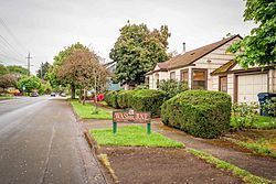
The Washburne Historic District in Springfield, Oregon was established in 1985 and added to the National Register of Historic Places (NRHP) in 1987. The district includes 29 full blocks and five partial blocks, and it is roughly bounded by A Street on the south, G Street on the north, Pioneer Parkway on the west, and 10th Street on the east. Its total area encompasses 84 acres.
Contents
Springfield General Hospital, now an apartment building within the district, is individually listed on the NRHP.
History
Named for banker and flour mill owner C.W. Washburne, the Washburne Historic District is part of an 1852 Donation Land Claim by Springfield founder Elias Briggs. The grid style blocks were platted from surveys between 1872 and 1890. Nearly 44 percent of surviving structures were completed between 1890 and 1915. Most of the district included paved streets and sidewalks by the mid-1920s.
Classification of buildings
The district includes five classes of buildings: