
Founded 1825 Website www.warrencountyil.com Population 17,726 (2013) | Area 1,406 km² University Monmouth College | |
 | ||
Rivers North Fork East Fork La Moine River | ||
Warren County is a county in the U.S. state of Illinois. According to the 2010 census, it had a population of 17,707. Its county seat is Monmouth.
Contents
- Map of Warren County IL USA
- History
- Geography
- Climate and weather
- Adjacent counties
- Demographics
- Airport
- Major highways
- State
- County
- Municipal
- Volunteer
- City
- Villages
- Townships
- References
Map of Warren County, IL, USA
History
Warren County was organized in 1825 out of Pike County which consisted of all portions of the state north and west of the Illinois River before 1825. Henderson County was formed in 1841 from the western area of Warren County.
Warren County was named for Dr. Joseph Warren, killed at the Battle of Bunker Hill in 1775. He is believed to have been the first officer to die in the Revolutionary War.
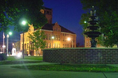
The current courthouse, constructed of red Portage stone, was completed in 1895.
Geography
According to the U.S. Census Bureau, the county has a total area of 543 square miles (1,410 km2), of which 542 square miles (1,400 km2) is land and 0.6 square miles (1.6 km2) (0.1%) is water.
Climate and weather
In recent years, average temperatures in the county seat of Monmouth have ranged from a low of 15 °F (−9 °C) in January to a high of 85 °F (29 °C) in July, although a record low of −27 °F (−33 °C) was recorded in February 1905 and a record high of 110 °F (43 °C) was recorded in July 1936. Average monthly precipitation ranged from 1.62 inches (41 mm) in January to 4.33 inches (110 mm) in July.
Adjacent counties
Demographics
At the 2010 United States Census, there were 17,707 people, 6,918 households and 4,617 families residing in the county. The population density was 32.6 inhabitants per square mile (12.6/km2). There were 7,682 housing units at an average density of 14.2 per square mile (5.5/km2). The racial makeup of the county was 91.3% white, 1.7% black or African American, 0.5% Asian, 0.2% American Indian, 0.1% Pacific islander, 4.5% from other races, and 1.6% from two or more races. Those of Hispanic or Latino origin made up 8.4% of the population. In terms of ancestry, 25.2% were German, 14.7% were Irish, 11.3% were English, 10.0% were Swedish, and 5.5% were American.
Of the 6,918 households, 29.6% had children under the age of 18 living with them, 52.2% were married couples living together, 9.7% had a female householder with no husband present, 33.3% were non-families, and 28.2% of all households were made up of individuals. The average household size was 2.40 and the average family size was 2.91. The median age was 39.6 years.
The median household income was $41,636 and the median family income was $49,623. Males had a median income of $40,289 and females $25,460. The per capita incomewas $20,047. About 11.0% of families and 13.4% of the population were below the poverty line, including 18.1% of those under age 18 and 10.6% of those age 65 or over.
Airport
Major highways
State
County
Municipal
Volunteer
Warren County/Monmouth Auxiliary Police Corps
City
Villages
Townships
Warren County is divided into these townships: