
OS grid reference TQ250261 Sovereign state United Kingdom Postcode district RH17 Dialling code 01444 | Post town HAYWARDS HEATH District Mid Sussex | |
 | ||
Warninglid is a small village in the Mid Sussex District of West Sussex, England. It lies on the B2115 road 5.5 miles (8.9 km) west of Haywards Heath. The name Warninglid is believed to originate from two words meaning "Werna's Path". It is in the civil parish of Slaugham.
Map of Warninglid, Haywards Heath, UK
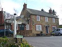
At the centre of the village is a crossroads, and there sits the Half Moon public house. Over the last quarter century the village has won the Best-Kept Village competition three times.
Education in the village is supplied by Warninglid County Primary School.
References
Warninglid Wikipedia(Text) CC BY-SA