
Established 1968 Founded 1968 | Postcode(s) 2611 Area 170 ha Postal code 2611 Population 2,597 (2011 census) | |
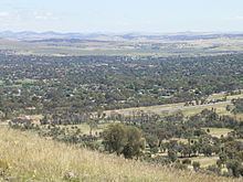 | ||
Waramanga (postcode: 2611) is a suburb of Canberra, Australian Capital Territory, Australia located in the district of Weston Creek.
Contents
- Map of Waramanga ACT 2611 Australia
- History
- Demographics
- Politics
- Geology
- Suburb amenities
- Educational institutions located in Waramanga
- Churches located in Waramanga
- Health facilities located in Waramanga
- Public Transport located in Waramanga
- References
Map of Waramanga ACT 2611, Australia
Waramanga was established in the late 1960s and was named after the Aboriginal tribe of Central Australia, also known as the Warumungu people.
History
The Weston Creek district was part of Yarralumla Station, a 40,000 acre (162 km²) property dating back to 1828. It was resumed by the Commonwealth in 1913 from Frederick Campbell who bought the property in 1881. In 1920 9,000 acres (36 km²) of the Woden Valley, including the Weston Creek district, were subdivided for soldier settlement leases. A 1950s map of the district shows four paddocks, Weston paddock, Track paddock, Brown Hill paddock and Oakey Hill paddock intersecting the area which is now the suburb of Waramanga. Long Gully Road ran through the suburb and the nearest homestead was Cooleman on the Kambah Road just west of the present suburb of Fisher. Cooleman was farmed by the Champion family from about 1932. It was previously known as Allawah and was leased to the Anderson family in 1920. Other properties in the district were Avondale and Weston whose homesteads were in the present suburb of Holder, Yamba in the suburb of Phillip and Iloura, Melrose and Yarra Glen in the suburb of Curtin.
In June 1968 the suburb of Waramanga was officially gazetted.
The bushfire which engulfed parts of Canberra on 18 January 2003 flowed out of Mount Taylor Nature Reserve and reached the eastern boundary of the suburb at Badimara Street where it was slowed by residents and stopped by a contrary wind. For more information about the bushfire see Canberra bushfires of 2003.
Demographics
On Census night 2011, Waramanga had a population of 2,597 people. Waramanga residents had a median age of 39 compared to a Canberra median of 34. The median weekly personal income for people aged 15 years was A$904 a week, compared to a Canberra wide figure of $917 and an Australia wide figure of $577.
The population of Waramanga is predominantly Australian-born, 73.4% of people being born in Australia. With 4.5% of the population, the second most common birthplace is the England. Accommodation is mostly separate houses (78.3%), with semi detached, row or terrace houses and townhouses comprising 18.1%.
Politics
Waramanga is located in the federal House of Representatives electorate of Canberra. Covering the southside of Canberra and southern ACT, the electorate of Canberra is currently represented by Gai Brodtmann of the Australian Labor Party. The two federal electorates in the ACT are safe or fairly safe ALP seats.
Waramanga is located in the ACT Legislative Assembly electorate of Murrumbidgee. Mainly covering Woden Valley, Weston Creek and the Molonglo Valley, the electorate of Murrumbidgee is currently represented by two Australian Labor Party members, two Liberal Party members and one ACT Greens member.
Geology
Deakin Volcanics green grey, red, and purple rhyodacite with spherulitic texture fill up Warramanga from beneath.
Suburb amenities
Waramanga has a busy local shopping centre located on the corner of Damala Street and Waramanga Place. The centre contains a supermarket, bakery, Malaysian restaurant, hairdresser, beauty salon, chemist, newsagency, medical centre and postal agency.
Educational institutions located in Waramanga
Churches located in Waramanga
Health facilities located in Waramanga
Public Transport located in Waramanga
Waramanga has extensive open spaces with playing fields on the western side of the suburb, several neighbourhood parks and pedestrian parkland along the ridge in the centre of the suburb. Waramanga is adjacent to Mount Taylor Nature Reserve, part of Canberra Nature Park with grassland and hillside walking tracks and sweeping views across Woden and Tuggeranong Valleys.