
Area 3,633 km² Established 1957 | ||
 | ||
Managing authorities | ||
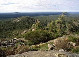
The Walpole Wilderness Area is a group of conservation reserves on the south coast of Western Australia. The area includes vast tracts of jarrah, tingle and karri forests surrounding granite peaks, rivers, heathlands, and wetlands. Coastal features include inlets and sandy beaches, sheer cliffs and the Southern Ocean.
Contents
The planning area, together with the Shannon and D'Entrecasteaux National Parks, provide a contiguous conservation reserve system stretching from near Augusta in the west to Denmark in the east.
The Walpole Wilderness incorporates:
History
The concept of a Walpole Wilderness Area was first developed by Donna Selby and Cath Roberts on behalf of the South Coast Environment Group Inc., in 1998. During the height of the old growth logging debate, the Walpole Wilderness proposal sought to realise the region's potential for nature conservation by proposing the creation of a Regional Wilderness Park which expanded and linked existing parks and reserves into a single integrated conservation reserve.
The proposal extended the concept of conserving the Shannon River Basin across the Deep River and Frankland River systems.
This proposal was also unique as it sought to integrate the Walpole/Nornalup townships and farming districts into the Area. It proposed the development of a unique relationship between local residents, visitors and the surrounding natural areas. It would facilitate the development of a wide range of nature-based recreational activities and maximise opportunities for associated business development. Existing recreational and tourism infrastructure would be enhanced and expanded to capitalise on the significant growth in tourism to the Walpole region, while concurrently ensuring the long term ecological and economic sustainability of the region.
The Walpole Wilderness area was adopted by the Western Australian Labor government by Premier Geoff Gallop on 22 April 2001.
Area
These areas have long been recognised for their unique natural, cultural, scenic and landscape values, in particular the rich array of endemic and nationally significant flora and fauna. The planning area is important for: