
District anjaw Telephone code wll | Time zone IST (UTC+5:30) Nearest city tinsukia | |
 | ||
Weather 22°C, Wind SW at 11 km/h, 78% Humidity | ||
Walong is a small cantonment and administrative town in the Anjaw District of the state of Arunachal Pradesh in northeastern India. Walong is also the easternmost town in India. Anjaw was carved out of Lohit District in 2004.
Contents
Map of Walong 792104
Geography
Walong's approximate position is 28 degrees 06 minutes North, 97 degrees East. It lies on the west bank of the Lohit River (a tributary of the Brahmaputra), approximately 20 kilometres south of the Chinese border. Just north of the border lies the Tibetan trading town of Rima.
The forest around Walong is rich in wildlife. Rare mammals such as Mishmi takin, Red goral and Leaf muntjac occurs while among birds there is the rare Sclater's Monal. A flying squirrel, new to science, i.e., Mishmi Hills Giant Flying Squirrel Petaurista mishmiensis also occurs in this district (site of a paratype).
History
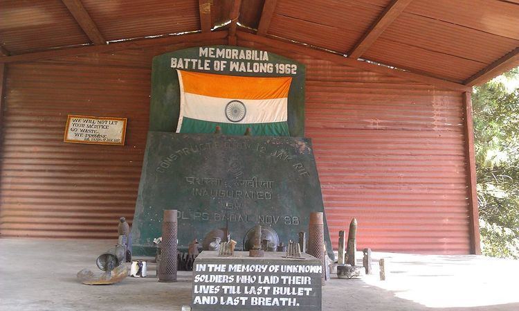
In autumn of 1962, during the Sino-Indian War, Walong was the scene of the battle of Walong, where the Indian Army 11th Infantry Brigade battled the Chinese advances. The Indians were defeated decisively by the Chinese. Only Mao's decision to withdraw the PLA allowed the Indians to retake Walong. A canopied memorial to the Indian war dead of 1962 was erected long ago next to the airstrip with the following verses composed by a Walong veteran inscribed on it:
The sentinel hills that round us standbear witness that we loved our land.Amidst shattered rocks and flaming pinewe fought and died on Namti Plain.O Lohit gently by us glidepale stars above us softly shineas we sleep here in sun and rain.Next to this is a marker relating the history of Walong ALG, and nearby the wreck of a Caribou which crashed here. A new large memorial to the Walong war dead of 1962 has come up in 2002 on the road leading North to Kibithu. Two small temples have also come up on 'Helmet Top', a hill position some 18 kilometres away, which was so named because of helmets and other military gear found strewn there.
Transport
Walong is approximately 200 km. by road from the district headquarters town of Tezu. It had an Advanced Landing Ground (ALG) which was capable of taking Otters and Caribous during the 1962 Sino-Indian War. Thereafter, it remained abandoned for a long time till 2013 when reconstruction of ALG began. The reconstructed ALG was inaugurated on 23 October 2015. There is an operational helipad.