
Builder [disputed] | ||
 | ||
Type linear monument, possibly road or dike Length between 1.2 and 25 miles (1.9 and 40.2 km) Similar Hole of Horcum, Coronation Chair, Newton Dale Halt railway st, Pickering Castle, Byland Abbey | ||
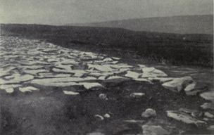
Wade's Causeway is a sinuous, linear monument up to 6,000 years old in the North York Moors national park in North Yorkshire, England. The name may refer to either scheduled ancient monument number 1004876—a length of stone course just over 1 mile (1.6 km) long on Wheeldale Moor, or to a postulated extension of this structure, incorporating ancient monuments numbers 1004108 and 1004104 extending to the north and south for up to 25 miles (40 km). The visible course on Wheeldale Moor consists of an embankment of soil, peat, gravel and loose pebbles 0.7 metres (2.3 ft) in height and 4 to 7 metres (13 to 23 ft) in width. The gently cambered embankment is capped with unmortared and loosely abutted flagstones. Its original form is uncertain since it has been subjected to weathering and human damage.
Contents
- Situation and geology
- Construction
- Extant course
- Possible extended course
- To the north
- To the south
- Legendary interpretations
- Causeway
- Wade
- Bel
- Skivick
- Discovery and initial records
- Pre war excavations
- Post war excavations and surveys
- Future archaeological work
- Theories on structures origins and purpose
- As a Roman causeway
- As a pre Roman or medieval road
- As a neolithic boundary structure
- Significance of uncertainty over the structures origin
- Site management in the modern era
- In fiction
- Other historic sites in close proximity
- References
The structure has been the subject of folklore in the surrounding area for several hundred years and possibly more than a millennium. Its construction was commonly attributed to a giant known as Wade, a figure from Germanic or Norse mythology. In the 1720s the causeway was mentioned in a published text and became known outside the local area. Within a few years it became of interest to antiquarians who visited the site and exchanged commentary on its probable historicity. They interpreted the structure as a causeway across marshy ground, attributing its construction to the Roman military, an explanation largely unchallenged throughout the eighteenth and nineteenth centuries.
The stretch of causeway on Wheeldale Moor was cleared of vegetation and excavated in the early twentieth century by a local gamekeeper with an interest in archaeology. Historian Ivan Margary agreed with its identification as a Roman road, and assigned it the catalogue number 81b in the first edition of his Roman Roads In Britain (1957). The causeway was further excavated and studied by archaeologist Raymond Hayes in the 1950s and 1960s, partially funded by the Council for British Archaeology. The results of his investigation, which concluded that the structure was a Roman road, were published in 1964 by the Scarborough Archaeological and Historical Society.
In the late twentieth and early twenty-first centuries, its identification as a Roman road has been questioned by academics, and alternative interpretations suggested for its purpose and date of construction. The monument's co-manager, English Heritage, in 2012 proposed several avenues of research that might be used to settle some of the questions that have arisen regarding its origins and usage.
Situation and geology
The area through which the Wheeldale structure runs is predominantly uncultivated heather moorland. Hayes believes its appearance has remained fundamentally unchanged since the Bronze Age when its forest cover was removed to permit cultivation and grazing. Wheeldale Moor is poorly drained in places making it susceptible to flooding in both the ancient[2] and modern eras. The underlying geology consists of patches of sand and gravel on top of mixed sandstone and oolitic limestone, known as Ravenscar Group strata.[3]
Construction
The causeway's visible section on Wheeldale Moor shows the remains of a continuous surface metalled with closely fitted slabs of sandstone[4] with flat upper surfaces.[5] The average size of a slab is 45 centimetres (18 in) square, but some examples are 1.5 metres (4.9 ft) in breadth. The purpose of a central ridge along one section of the causeway, described in two independent excavations, is unknown. The stone flags are seated on a cambered base of mixed gravel, clay and either rubble, peat or soil, that forms a raised embankment. The embankment is from 3.6 to 7 metres (12 to 23 ft) wide [6] at its raised surface. Its width in some sections is increased by 1 metre (3.3 ft) of ditch to either side, which may or may not be associated with its original construction, making an approximately uniform total width of 5 to 8 metres (16 to 26 ft).[7] Its height above surrounding soil level is approximately 0.4 metres (1.3 ft).
Hayes and Rutter state that the primary purpose of such an embankment would have been to provide good drainage for a road surface. Archaeologist David E Johnston states that the structure is crossed by numerous perpendicular drainage culverts with small becks trickling through them since the ground is often boggy. This could suggest a reason for the embankment, and its early attribution as a causeway—a route across wetland, normally supported on earth or stone in the form of a raised embankment. Nineteenth-century antiquarian Thomas Codrington argued that Roman roads in Britain were generally built on embankments regardless of the underlying ground's drainage. He states that the common appellation of "causeway" in the names of Roman roads may, therefore, relate to their embankments rather than indicate that the ground on which they were constructed was ill-drained. Some historians translate Livy's phrase for Roman military construction of roads, via munire, as "making a causeway".
Johnston, historian Nikolaus Pevsner and landscape historian Richard Muir all agree that an original gravel surface dressing was once present on top of the stone of the Wheeldale structure. Whereas Johnston and Pevsner believe that the gravel was washed away through weathering,[8] Muir states that human agents were primarily responsible for its removal. Both agree that the stonework remaining does not represent the original road surface. Statements by the eighteenth-century antiquary Francis Drake and nineteenth-century topographer Samuel Lewis that the writers found it to be "paved with a flint pebble" may support this theory,[9] although Hayes and Rutter cast doubt on the accuracy of Drake's reports.[10] Codrington states that in 1817 the causeway consisted of a "strong pavement of stones ... [with] above these another stratum of gravel ...", Hayes and Rutter state that "traces of a surface layer of gravel and small stones" remained visible in the 1960s, and professor of structural engineering John Knapton states that there remained some evidence of smaller surface-dressing pebbles as late as 1996.
Codrington and archaeologist Frank Elgee consider the structure was flanked in a few sections by lateral parallel ditches but Hayes is doubtful whether they were part of the original construction or if they even existed.
Extant course
The excavated portion of the Wheeldale structure—the only section of a postulated greater extent that remains clearly visible to the naked eye—consists of a 1.2 miles (1.9 km) section on the eastern edge of Wheeldale Moor, facing Howl Moor. It runs in an approximately north-northeasterly direction between grid reference SE 80344 97382 and grid reference SE 81077 98697, and is approximately 185 to 200 metres (607 to 656 ft) above sea level. The presence of large quantities of stone on a raised agger, and the absence of much vegetation on its surface, make the presence of the structure indisputable along this section.[11] The causeway's course is linear along its visible section on Wheeldale Moor, consisting of several short, straight sections that pivot occasionally onto new alignments in a way not clearly demanded by the landscape. In 1855, several overgrown fragments of the structure were also reported visible at several points in the vicinity: near Morley Cross; east of Keys Beck; near Hazle houses; at July Park; and at Castle Hill.
Possible extended course
The structure is believed by several writers to extend far beyond its visible portion,[12] but no significant sections of its conjectured course remain visible to the naked eye or have been excavated or extensively surveyed, and there is little agreement on an exact course that an extension may have taken. The total original length of the structure is therefore unknown, but may have been up to 25 miles (40 km).[13]
To the north
Early records of the causeway's course to the north—when its remains were apparently more readily visible than today—differ considerably from one another: the early geologist and natural historian George Young, who wrote in relation to the causeway in his History of Whitby, makes no clear mention of the route of the structure north of Wheeldale Moor; it is unmarked on the 1854 Ordnance Survey map of the area; and eighteenth-century historian Thomas Hinderwell's mention of it passing near Hunt House suggests a greatly differing route to that marked on 2012 Ordnance Survey mapping. At least one source states that a "conjectural" continuation to the north is visible in vertical aerial photography. Hayes reports that in his survey in the 1950s, he found "trace of the embankment" in one short section and "a patch of the metalling" in four additional sections along a route past Hazle Head and Julian Park.
Beyond Julian Park, it has been conjectured that the structure originally continued to the Roman garrison fort at Lease Rigg, south west of Sleights, based on reports from antiquarians in the eighteenth and nineteenth centuries that fragments were visible at numerous points along this course. Hayes and Rutter appear confident of the structure's extent as far as Lease Rigg, but admit that its extent is conjectural from well short of that point, from Dowson Garth Quarry northwards.
Numerous authors have conjectured that the structure was a road that continued past Lease Rigg all the way to Roman coastal fortifications or signal stations somewhere near Whitby,[14] but this is debated. Drake reports in 1736 that an associate had followed its course from Wheeldale Moor to the coast at Dunsley Bay, but Codrington is dismissive of his account, and whether the author meant to imply that a visible structure had been followed, or simply that the associate had followed a proposed route without encountering it, is unclear. In either case, the author did not verify sight of the structure along this course himself. Several sources after 1805 report the same endpoint for the road[15] but it is unclear whether they are echoing Drake or had visited the site themselves. Several authorities state that any termini beyond Lease Rigg are "doubtful" and "unproven", and Elgee states that the causeway's northern course "is obscure and its termination unknown". Hayes and Rutter in 1964 found no evidence for a continuation of the structure any further north than Lease Rigg. Other authorities argue for possible courses extending northwards to Goldsborough,[16] Guisborough, or Sandsend Bay.
To the south
It has also been suggested that the structure originally extended southwards from Wheeldale Moor to link up to the Roman Cawthorne Camp (sometimes spelled 'Cawthorn').[17] In the twentieth century English Heritage identified two sections of ground on Flamborough Rigg and Pickering Moor as extensions of the Wheeldale structure.[18] Hayes states that the Flamborough Rigg section remained "clearly visible" as late as 1961, and that additional sections near Keys Beck were visible in aerial photography from 1946. The accounts of Hinderwell, Young, and Hayes & Rutter, as well as the 1854 and 2012 Ordnance Survey maps, appear to corroborate the stated course of the structure along this section.
There is further conjecture that the original structure's course may have gone beyond Cawthorne Camp to the Roman settlement of Derventio Brigantum (possibly either Stamford Bridge[19] or modern-day Amotherby near Malton).[20] Any postulated extension further south than Cawthorn is contested. Hinderwell reports in 1811 that the late Robert King had found evidence of a continuation of the causeway between "Newsom-bridge" and Broughton (a former township located near Appleton-le-Street). Hayes and Rutter failed to find any trace of the causeway south of Cawthorn along a route via Amotherby, Barugh or Newsham in their survey in the 1950s,[21] and note that its course could not be determined as early as 1726.
Beyond Malton, there is a postulated stretch of Roman road leading towards York, which it is possible may be an extension of the causeway. Evidence for it is very slim: it is mentioned by Drake in 1736, but Codrington could find no trace of it in 1903, and writes that there is "some uncertainty as to the connexion". Archaeologists Philip Corder and John Kirk reported a possible section of Roman road at Brandrith Farm (grid reference SE 698692) in 1928, but it is unknown whether this relates to the same structure as Drake observed, or has any association with the Wheeldale structure.
Legendary interpretations
Historian Hector Munro Chadwick states that historical explanations for ancient structures would have been known to educated clergymen from the seventh century, but that structures were generally named by less educated people, often after mythological characters. Oral folklore in the North York Moors area from the Early Middle Ages has not generally survived into the modern era, but social historian Adam Fox states that the attribution of the causeway to Wade existed in oral folklore dating from at least as early as the Renaissance era. The folklore held that the causeway was built by a giant called Wade for his wife to take her cow[22] to either market or pasture.[23] In 1890, historian Thomas Bulmer records that:
The legend of Wade and his wife are reflected in alternative names for the structure that include "Old Wife's Trod",[24] "Auld Wife's Trod"[25] and "Wade's Wife's Causey". The folklore of Wade was still common locally in the early nineteenth century. There is some confusion as to whether the name Bel or Bell relates to Wade's wife, or to his cow. Bulmer refers in 1890 to "[Wade's] wife, Bell" and Young also assigns the name to Wade's wife in 1817. Hayes (1964) accepts this attribution but antiquarian Hilda Ellis Davidson believes that the folkloric Bel refers to Wade's cow and reflects an earlier tradition of the "fairy" or bountiful cow. The earliest published source of the legend, from 1779, is ambiguous and refers to "Bell Wade's cow".
Causeway
Several of the earliest sources refer to the structure as "Wade's Causeway",[26] "Wade's Causey",[27] and "Wade's Wife's Causey". The word causeway derives from the earlier English causey way or simply causey. Causey derives from the Middle English cauci, which derives from the Anglo-French causee, itself derived from the Medieval Latin calciata ("paved highway"), which ultimately may derive from the Latin calx (meaning "heel"). The derivation from calx can most likely be explained by the practice in the Ancient Roman era of consolidating earthworks through trampling with the heel of the foot.[28]
Wade
It is not known for certain who the causeway is named after, but the figure was at the latest pre-Renaissance, and the majority of sources agree that it has its origins in the medieval period or earlier.[29] The name Wade appears as one of the most common surnames in a 1381 poll tax register from Suffolk, and philologist P H Reaney reports multiple instances of it from the 11th and 12th centuries. The names Wade or Wada were common in pre-medieval English history[30] and historian William Searle records around a dozen historic Wades in his Onomasticon of early Anglo-Saxon names.[31] The earliest figure from the region identified as Wade in extant writings is Duke Wada, a historical personage of Saxon descent who is recorded in 1083 as having been a prominent figure living in the Yorkshire area around 798.[32] It is possible that this person was either named after—or has been conflated over time with—one of several earlier, mythological figures known as Wade.[33] Chadwick states that it is most probable that the causeway is named directly after a well-known mythological, rather than historical, Wada.
The earliest origins of tales relating to a mythological Wade are confused and diverse. Linguist George McKnight states that the epic of Wade, although becoming a "mass of tales ... of the most diverse origin imaginable", was one of only a few clear examples of an epic from the Early Middle Ages surviving into Middle English. Geoffrey Chaucer, writing in the fourteenth century, makes reference to early English legends of Wade but these no longer exist in their complete form. Walter Map, writing in the twelfth century, also mentions a Vandal prince Gado (thought to be a Latin form of Wade) in his fantastical lay De Nugus Curialium.
The Wades in these early English works likely relate to one or more earlier legendary figures known as Wade, or variations thereof, in Northern European folklore and legend.[34] Various authors suggest links to: the giant Vaði, (also known as Witege, Vathe, Vidia, Widga, Vidga, Wadi or Vade) mentioned in the Norse Saga of Bern in the Þiðrekssaga;[35] the Danish hero Wate, also called Wada; the Anglo-Saxon deity Wōden (also Wōđanaz or Wōđinaz),[36] who was historically referred to as "heaven's giant"; and the German figure Wa-te, a fierce sea-king similar to Neptune, who reigns in Sturmland in the 7th-century saga Kudrun.[37] Nurse and Chadwick identify all the above figures as being later facets of a single legendary character present in an early, shared mythology of tribes living around the rim of the Baltic and North Seas.[38]
There are possible etymological links between Wade's causeway and other UK archaeological sites: Wade's Gap on Hadrian's Wall in Northumbria;[39] the Wansdyke that runs between Wiltshire and Somerset; and Wat's Dyke in the Welsh borders: all three have pre-modern origins and the latter two have sections contested as Roman in part.[40]
Bel
There have been too few published studies on the etymology of the figure of Wade's Bel (whether that refers to his milkmaid wife or to the cow) to provide a firm etymological or mythological basis. Wade is firmly rooted in Norse mythology[41] and there are parallels between Wade's cow/milkmaid wife Bel and the milkmaid figure of Beyla in Norse mythology, who some authorities have suggested derives etymologically from baula, meaning cow.[42] There is no published work suggesting such a link, so the origin of the figure remains unproven.
Skivick
It is thought that Skivick or Skivik, the local name for the section of structure visible on Wheeldale Moor,[43] could derive from two morphemes from Old Norse. The first syllable could derive from skeið, which could mean either a track or farm road through a field, or from a word used to describe a course or boundary.[44] The second syllable could derive from vík, meaning a bay[45] or a nook between hills. Scandinavian or Norse place-names are common in Yorkshire and Norse peoples settled in the Yorkshire area from 870 AD onwards[46] following raiding over the previous seventy years. Sawyer states that early Norse colonists had a profound effect on place-names in the areas in which they settled. Sedgefield states that the skeið derivation specifically in place-names within northern England points to Scandinavian settlement of the area, but that due to the inheritance of language across generations, a place-name containing skeið may in any individual case have been applied any time between the ninth and fifteenth centuries. Historian Mary Atkin states that skeið place-names appear near Roman sites frequently enough to suggest an associative link.
Discovery and initial records
The sixteenth-century antiquarian John Leland passed through the area in around 1539 when compiling his Itineraries of local English history and mentions the nearby and mythologically-linked "Waddes Grave" – standing stones at Mulgrave near Whitby. He appears not to have had Wade's Causeway brought to his attention by local antiquarians, since he makes no mention of it. In 1586, antiquarian William Camden makes passing note of the fact that, in parts of England, locals take "Roman fabriks to be the work of Gyants", but, although mentioned in the context of Roman roads, this appears to refer to the folklore of the time in general rather than to Wade's causeway specifically. He makes no mention of Wade's causeway by name, despite having toured the area, which—as Drake remarks in 1736—is "odd ... when he was upon the spot".
The first modern written record that unquestionably relates to the Wheeldale structure was in 1720 by the antiquarian John Warburton. This first publication of the existence of the structure was followed by debate over the structure's function, course and history amongst local historians and antiquarians in the eighteenth and nineteenth centuries, as its existence came to broader attention. In a private letter dating from October 1724, Thomas Robinson of Pickering states that approximately 6 miles (9.7 km) of the structure, which he describes as a road, were visible at that time, stretching south from Dunsley village:
Drake personally visited and examined a length of the structure and incorporated its description into one of his published works (1736). The causeway was also mentioned in nineteenth century publications by Walley Oulton (1805), Thomas Hinderwell (1811), George Young (1817), John Phillips (1853), Robert Knox (1855), George Bevan (1884), John Atkinson (1894) and Ralph Horne (1897); and in the twentieth century by Thomas Codrington (1903), Boyd Dawkins, A Austen (1903), Frank Elgee (1912,1923,1933), Kitson Clark (1935), Ivan Margary (1957), Hayes & Rutter (1964) and Nikolaus Pevsner (1966).
Pre-war excavations
The first recorded excavations of the structure are in the Victorian era: after performing some preliminary clearing of a part of the Wheeldale Moor section of the causeway in the 1890s, Wheeldale Lodge gamekeeper James Patterson[48] persuaded the Office of Works (now the Department of the Environment) in 1912 to transfer into its stewardship the full 1.2 miles (1.9 km) stretch of the causeway over Wheeldale Moor.[49] Working alongside Oxley Grabham from the York Museum, members of the Yorkshire Archaeological Society and several private individuals, Patterson cleared and excavated the adopted stretch of causeway between 1910 and 1920.[50] A further section, near Grosmont Priory, was excavated by Hayes between 1936 and 1939.
Post-war excavations and surveys
Historic England's PastScape website mentions further, minor, excavations of small sections of the causeway in 1946 and 1962, and archaeologist Hayes relates extensive excavations that he carried out between 1945 and 1950 at Riseborough, Cawthorn, Flamborough Rigg, Lease Rigg, Grosmont Priory and to the west of Aislaby. This work was partially funded by the Council for British Archaeology, and his findings published in an extensive study titled Wade's Causeway in 1964. The previous year the course of the structure across Wheeldale was surveyed by the Whitby Naturalists Club. English Heritage have also published records of later survey works by the Royal Commission on the Historical Monuments of England (1981) and Plowman Craven and Associates (1984).
The Royal Commission on the Historical Monuments of England (RCHME) undertook a theodolite survey of the causeway in 1992, and some limited excavations and analysis were carried out in 1997 during maintenance work on the structure.[51] The most recent published survey that has been performed is an aerial survey carried out in 2010/2011 by Archaeological Research Services Ltd (ARS) as part of English Heritage's National Mapping Programme.[52]
Future archaeological work
Professor Pete Wilson, on behalf of English Heritage's Portico Properties Research Project, has suggested questions for future research and investigation of the site, including: excavation to establish its date and function; examination of historic documentation for medieval mention of use of the monument as a route or in a boundary dispute; and analysis of the site via a detailed aerial survey, lidar or other remote sensing technique to establish the extent of the monument beyond the length so far excavated.
The possibility also exists to apply newer techniques such as optically stimulated luminescence (OSL) testing to attempt to date any bricks, pottery, or other fired materials found in situ in the structure, a method that was successfully used in the identification of a suspected Roman road near Bayston Hill in Shropshire.
Theories on structure's origins and purpose
A wide variety of interpretations for the structure have led, in the absence of any hard evidence, to a broad range of proposed dates for its construction, from 4,500 BC to around 1485 AD.[53] In archaeological excavations, no coins or other artefacts have been found on or around the structure to aid its dating,[54] and no evidence has been gathered as of 2013 through radiometric surveys. This has led to great difficulty in establishing even an approximate date for the causeway's construction. Attempts to date the structure have therefore relied on less precise means including etymology,[55] the structure's probable relationship in the landscape to other structures of more precisely established date and function,[56] and the comparison of the causeway's structure and fabrication to structures such as Roman roads.[57]
As a Roman causeway
The first antiquarians to discuss the site in the eighteenth and nineteenth centuries, dismissed early folkloric explanations of the structure's origins. Roman roads were of particular interest to eighteenth-century antiquarians, and they sought to explain the Wheeldale structure in the context of Roman activity in the North York Moors area in the first and second centuries AD. Specifically, it was commonly suggested in their writings that the causeway was most probably constructed to connect the Roman Cawthorne Camp to the south with the Roman garrison fort at Lease Rigg near Grosmont to the north. The excavated section of the structure does lie in a linear fashion approximately between these two sites, which Knight et al. believe lends credence to its being of Roman origin. Its average reported width of approximately 5.1 metres (17 ft) plus 1 metre (3.3 ft) wide lateral ditches flanking either side matches closely to the width of other Roman roads in Britain (e.g. Stanegate at 6.7 metres (22 ft)) as well as to the average of 7 metres (23 ft) for Roman roads internationally; historian John Bigland, writing in 1812, also states that there is no other plausible alternative for the structure's scale and method of construction than "Roman industry and labour".
One objection to identifying the road as Roman was that, based on readings of the Iter Britanniarum—the section of the 4th-century Itinerary of Antoninus that lists major Roman Roads and stations within Britain—there had never been any major Roman roads in the area. In 1817, Young attempted to address this problem by arguing that the course of one of the identified iters (iter 1) had been misinterpreted and ran between Malton and Dunsley, passing through Wheeldale. Such an argument was possible because the Iter Britanniarum was not a map, but rather a list or itinerary of roads and their distance between various settlements. Roman names for settlements were used in the document and, since many of these named sites had not been conclusively matched to contemporary settlements, identification of exact routes listed in the Iter was often difficult. There were few other objections at the time to the causeway's identification as a Roman road and by the twentieth century the causeway was commonly being referred to as the "Wheeldale Roman Road",[58] or "Goathland Roman Road".[59]
There was also support for the identification of the structure as a Roman road on etymological grounds. The early twentieth-century literary scholar Raymond Chambers argued that the name "Wade's causeway" is an example of Angle and Saxon settlers arriving in Britain and assigning the name of one of their heroes to a pre-existing local feature or area: if his argument that the structure was given its current name sometime during the Saxon era—between approximately 410[60] and 1066[61] AD—is accepted, then it must have been constructed prior to these dates. Atkin reaches a similar conclusion, arguing that the Norse morpheme skeið that is a partial root for Skivick, a local name for a section of the structure, is commonly found amongst Roman structures that are discernible by later Saxon or Viking settlers. Hayes and Rutter also identify the structure as a Roman road, but using a quite different etymological argument: they state that there is an absence among the names of settlements along the causeway of the Anglo-Saxon morphemes ceaster and stret and that, as per Codrington, these morphemes would be expected to be found in the names of several sites that lie alongside a former Roman road. They conclude that the absence of settlements with such names along the postulated extended course of Wade's Causeway indicates that the structure must already have been abandoned and of little significance by the Anglo-Saxon period (c. 400–600 AD), most likely by around 120 AD, and must therefore be of early Roman origin.
Several authorities who accepted the structure's interpretation as a Roman road attempted to make more precise estimates of the date of its construction by identifying periods of Roman military activity in the region, since the majority of Roman roads were of military construction.[62] Historian Albert Norman, writing in 1960, states that the Wheeldale structure most probably dates from either the first or fourth century AD but most sources appear to favour a first-century date: both historian Brian Hartley and Hayes & Rutter estimate around 80 AD;[63] and Elgee estimates 86 AD. The earlier, first-century, estimates assume that the road is Roman and that Roman road-building in the region occurred around the time that Gnaeus Julius Agricola was the Roman governor of Britain. Agricola made a concerted effort to expand and consolidate Roman control over lands of the Brigantes tribes in the North York Moors area in the 80s AD[64] and is thought to have ordered the construction of nearby Lease Rigg fort. The fourth-century estimates, by contrast, assume that the tribes in the North York Moors area were either bypassed or subdued in the first century but that, being of little importance strategically, their lands were not subject to Roman occupation or construction until the fourth century. A second wave of Roman military activity appears to have occurred in the region during this later period in response to new military incursions and raiding by Saxons, Picti, Scoti and Attacotti.[65] The east coast of the North York Moors area formed the northern flank of the Saxon Shore defences believed to have been constructed against this perceived threat.[66]
The above explanations all place the causeway within a Roman military context. An alternative, or perhaps secondary, usage for the causeway in Roman times is suggested by landscape author Michael Dunn and others, who state that it may have been constructed for the transport of jet inland from Whitby.[67] Hayes and Rutter are dismissive, stating that the value of jet mined in the Roman period would not have justified the expense of the causeway's construction.
A possible issue with the causeway's identification as a Roman structure in the latter half of the twentieth century was its incorporation of many small bends along its course. Roman military roads[68] are usually straight in both their overall course,[69] and also typically from one vantage point to the next.[70] Both the Foss Way and the Stanegate,[71] roads of established Roman provenance, have sinuous courses similar to Wade's causeway, so the objection is not conclusive.
The use of dressed stone rather than gravel as a surface dressing was also occasionally held to be a sign against the causeway being of Roman construction: the majority of Roman roads that were finished with a material other than simple packed earth were dressed in either packed gravel or pebbles.[72] There are other examples of Roman roads paved with stone blocks, including the 11 miles (18 km) section of the Via Appia—the oldest major Roman route in Italy—near Albano. Historians Richard A Gabriel and Michael Grant state that of the 400,000 kilometres (250,000 mi) of known Roman roads, over 80,000 kilometres (50,000 mi) may have been stone-paved.[73] The Roman writer Ulpian specifically differentiates between via munita, which always had a paved stone surface, and via glareata, which were earthed roads with either gravelled surfaces, or a gravelled subsurface and paving on top. The causeway may well have had a gravel surface dressing originally, which has been removed since through robbing and natural weathering. Another difference in construction detail between Wade's Causeway and a typical Roman road is its lack of a foundation of large stones. Codrington and archaeologist John Ward stress that the structure of Roman roads varied greatly depending upon their situation and the materials available, especially within Britain.[74]
For much of the twentieth century, the consensus remained that the road was most probably Roman. It was still referenced as an undoubted Roman road in a 1947 UK Government report and in 1957 Margary, the leading authority on Roman roads at the time, accepted the road as Roman and assigned it the catalogue number 81b in his list of Roman roads in Britain. In the late 1950s and early 1960s this was a definitive and unquestioned interpretation of the monument.[75] Several works in the 1980s and 1990s stated that Roman-era road construction was still the most probable explanation of the structure.[76]
As a pre-Roman or medieval road
Whilst nineteenth- and to a lesser extent twentieth-century[77] attitudes often suggested that any well-constructed pre-modern road surface must be Roman,[78] late twentieth-century archaeologists were more open to evaluating the structure within the context of a wider span of historical periods. After an early allowance by Phillips in 1853 that the causeway could be British rather than Roman there was little further investigation of such a possibility. In 1994, the Royal Commission on the Historical Monuments of England began a review of the date or origin for the Wheeldale causeway. Detailed air photography of the Cawthorn camps in 1999 site failed to find evidence of a road leading towards Wheeldale Moor from the camps to which it is historically related, and the causeway does not obviously connect to the main Roman road network. Several writers around the turn of the millennium began to express doubt about the established narrative for the structure as a Roman road.[79] Twenty-first century archaeologists then found several exemplars of other cambered, metalled roads that pre-date the Roman presence in Britain,[80] and hence set precedence for the possibility of a pre-Roman origin for the Wheeldale causeway. Several sources from the mid-1990s onwards have suggested that the structure may be a pre-Roman (Iron Age) road of uncertain route or purpose.[81]
Blood and Markham (1992) have proposed an interpretation of the structure as a post-Roman (medieval) road, possibly relating to the wool trade,[82] although this is harder to reconcile chronologically with etymological explanations for the structure's naming. English Heritage state that it is "quite possible" that the causeway was used as a road during the medieval period despite being built much earlier.[83] Similarly Hartley, whilst accepting the structure as a Roman military road, believes it is unlikely that the causeway immediately fell out of use once its military use ceased. Drake recorded that by 1736 the causeway was "not now made use of", but there is no historical record covering its possible use as a road during the medieval period.
As a neolithic boundary structure
There are some objections to the interpretation of the structure as being a road at all, including the fact that several burial cists along the structure's course protrude through its surface by up to 0.4m, highly unusual for a road surface. Since 1997, authorities including English Heritage have accepted the possibility that the structure may not be a road. Archaeological consultant Blaise Vyner suggested in 1997 that the structure may be the collapsed and heavily robbed remains of a Neolithic or Bronze Age boundary wall or dyke. There are other Neolithic remains on the North York Moors, including boundary dikes,[84] although Knight et al. report that the later Neolithic is very poorly represented archaeologically in the North York Moors area and neolithic use of the moors was likely very limited in extent. Bronze Age presence in the moors, including earthworks, is well represented generally in the archaeology of the area, and therefore is a more plausible origin. Evidence against the identification of the causeway as an early Neolithic structure includes the statement by Elgee in 1912 that the causeway had been identified as cutting across an earlier British earthwork just north of Julian Park, suggesting that it must post-date it. One possibility that could explain several of the anomalies in trying to definitively identify the site is the suggestion by Knight et al. that it was commonly observed practice in the area for dykes to be reused as trackways.
To account for the uncertainty regarding the structure's original function, the term "Wheeldale Linear Monument" was introduced in the 2010s to refer to the structure. English Heritage in 2013 stated that the balance of opinion had swung to favour a prehistoric, rather than Roman, origin for the structure. As of 2013, the uncertainty regarding the monument's purpose and origin is reflected by the information board at the end of the Wheeldale section of structure, where it meets the modern road. The original sign, pictured in 1991 states that the structure is a Roman road, whereas new signage installed in 1998 admits that the origin and purpose of the structure are unknown.
Significance of uncertainty over the structure's origin
If Wade's Causeway is conclusively determined to be other than a Roman road, it would not be the only example of long-standing misattribution of ancient structures as Roman roads. The most famous example is the Blackstone Edge Long Causeway, which was once acclaimed as one of the finest surviving Roman roads in Britain, and a structure around which there was "no doubt that ... [it] ... is Roman". It was accepted as Roman by archaeologists Hayes and Rutter, who also identified Wade's Causeway as Roman. Archaeologist James Maxim in 1965—a year after Hayes and Rutter published their findings on Wade's Causeway—stated that he had found a medieval pack-horse trail passing under Blackstone Edge, which it must therefore post-date. Subsequent research by the archaeological unit of the University of Manchester claimed that the Blackstone Edge road was most probably a turnpike dating from around 1735.
Site management in the modern era
The surviving section of the causeway on Wheeldale Moor was reported by 1903 to be overgrown with heather and up to a foot of soil. After being cleared of debris and overgrowth during excavations from 1910, it was by 1920 "stripped ... of the growth of turf and heather and ... perfectly clear for miles". The Office of Works then employed a labourer to keep the section of causeway on Wheeldale Moor clear of vegetation, an arrangement that appears to have survived after that organisation's change to the Ministry of Works in 1943[85] and later absorption into the Department for the Environment in 1970. Johnston states that the site was still maintained in 1979, but by 1994 the visible section of the causeway had been left to be covered by vegetation once more.[86]
Hayes and Rutter state that the greater postulated portion of the structure beyond that visible on Wheeldale Moor is difficult to trace due to its having been greatly damaged over the years by natural erosion, which they state has completely destroyed some sections. The structure as a whole has also been greatly damaged both deliberately and inadvertently by humans: as Ward writes, it is often the fate of historic structures such as roads to have "been levelled by the plough and plundered of their materials". There are specific mentions of damage to the causeway through ploughing,[87] tree felling, the laying of water mains, attempts to clear vegetation and even, in the twentieth century, by the activity of both tracked and armoured vehicles. The structure has also been heavily and deliberately robbed of stone for use in local construction, such as roads,[88] dry-stone walls, dikes[89] and farm buildings, this robbing continuing from 1586[90] through to at least the early twentieth century.[91] Young, writing in 1817, laments the robbing of stone from the causeway for use in the construction of a modern field boundary, writing:
A change in attitudes, and awareness of the historical significance of the structure, led to a gradual shift from destruction to preservation in the late nineteenth and early twentieth centuries. English Heritage state that limited repair work or alterations on the structure were likely carried out in the nineteenth century, but exact details are unclear. In 1913 the Wheeldale structure was brought under legal protection from robbing and deliberate damage, when its conservation was guaranteed under the Ancient Monuments Consolidation and Amendment Act.[92] In 1982 a proposal was made to re-cover the majority of the exposed section with topsoil in order to protect it from further damage, but this has not been carried out as of 2013. There was some further, limited maintenance of some sections between 1995 and 1997 to control water erosion,[93] in addition to major erosion repair at the southern end of the structure in 1997.
There has been at least one report of deliberate vandalism to the structure,[94] but the primary concern relating to visitors to the site is the possibility of damage caused through tread wear. The site is not heavily trafficked and any wear to the structure since the 1980s would likely be mitigated by the protection from the natural re-establishment of plant growth over its surface.[95] Updates by the North York Moors National Park authority and English Heritage suggest that natural weathering[96] and grazing sheep represent greater erosion risks to the structure than do human agents.
As of 2013, the site is managed by the North York Moors National Park Authority, in cooperation with English Heritage, through a Local Management Agreement. English Heritage do not man the site and permit free access at any reasonable time. The site receives up to a thousand visitors per month.[97]
In fiction
Scottish Author Michael Scott Rohan drew on the legend of Wade's Causeway, as well as wider English, Germanic and Norse mythology, when he wrote his Winter of the World trilogy while living in Yorkshire. The books feature mention of a legendary giant, Vayde, who ordered to be built a causeway across the marshes.
Other historic sites in close proximity
English Heritage recognises the following historically significant sites in close proximity to Wade's Causeway: