
Demonym(s) Waddinxvener Postcode 2740–2743 Area 29.39 km² Local time Thursday 7:33 PM | Elevation −2 m (−7 ft) Time zone CET (UTC+1) Website www.waddinxveen.nl Area code 0182 | |
 | ||
Weather 9°C, Wind NW at 10 km/h, 68% Humidity | ||
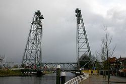
Waddinxveen ( [ˌʋɑdɪŋksˈfeːn]) is a town and municipality along the Gouwe river in the western Netherlands in the province of South Holland near Gouda. The municipality had a population of 25,555 in 2014 and covers an area of 29.40 km2 (11.35 sq mi) of which 1.50 km2 (0.58 sq mi) is water.
Contents
Map of Waddinxveen, Netherlands
In Waddinxveen, there's the so-called 'Vergeten Plek' (Dutch for 'Forgotten Place'). This is the lowest place in the Dutch polders. It's 7.01 meters below Amsterdam Ordnance Datum.
Partner city of Waddinxveen is Pelhřimov in the Czech Republic.
History
The first reference to the area is from 1233, when on April 20, Floris IV, Count of Holland, sold an area of peat lands along the Gouwe River for 200 Dutch pounds to Nicolas of Gnepwijk, Lord of Aalsmeer and Woubrecht. The area was given the name "Waddinxvene". Because of this event, Waddinxveen celebrated its 750-year anniversary in 1983.
Between 1817 and 1870, Waddinxveen was dissolved and its area split into the municipalities of Noord-Waddinxveen and Zuid-Waddinxveen. Due to further expanding, those two municipalities reunited into one.