
Time zone CET/CEST (UTC+1/+2) Area 7.84 km² | Elevation 40 m (130 ft) Postal codes 12529 Postal code 12529 Dialling code 03379 | |
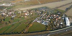 | ||
Waßmannsdorf is a village and a civil parish (Ortsteil) of the German town of Schönefeld, located in the district of Dahme-Spreewald in Brandenburg. As of 2007 its population was of around 1,000.
Contents
Map of Wa%C3%9Fmannsdorf, Sch%C3%B6nefeld, Germany
History
First mentioned in 1350 as Wasmanstorp, the village was an autonomous municipality until 2003, when it merged into Schönefeld. From 1961 to 1989 its municipal borders with West Berlin were crossed by the Berlin Wall.
Geography
Waßmannsdorf is located in the southeastern suburb of Berlin, near the districts of Tempelhof-Schöneberg, Neukölln and Treptow-Köpenick; and bordering with the quarter of Rudow. The nearest places are Großziethen, Selchow, Schönefeld and Blankenfelde-Mahlow. The village is 20 km far from Königs Wusterhausen, 28 from Ludwigsfelde and 34 from Potsdam.
Transport
Waßmannsdorf is situated close to the runway of Berlin Schönefeld Airport, that will be merged into the new Berlin Brandenburg Airport in 2017. Crossed by the Berlin outer ring, it will be served by a new railway station on the S-Bahn extension to the new airport (lines S45 and S9). The village is also interested by the Expressway Potsdam-Schönefeld projects.