
Admin. region Unterfranken Elevation 126 m (413 ft) Population 4,835 (31 Dec 2008) | Time zone CET/CEST (UTC+1/+2) Local time Thursday 8:36 PM | |
 | ||
Weather 10°C, Wind W at 6 km/h, 53% Humidity | ||
Wörth am Main (officially Wörth a.Main) is a town in the Miltenberg district in the Regierungsbezirk of Lower Franconia (Unterfranken) in Bavaria, Germany. It has a population of around 4,700.
Contents
- Map of 63939 WC3B6rth am Main Germany
- Location
- History
- Arts and culture
- Museums
- Buildings
- Transport
- Town twinning
- Mayors
- References
Map of 63939 W%C3%B6rth am Main, Germany
Location
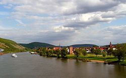
Wörth am Main lies on the left bank of the Main, nestled between the hills of the Odenwald and Spessart, 13 kilometres (8 miles) northwest of Miltenberg, and 19 kilometres (12 miles) south of Aschaffenburg.
Wörth lies in the Bavarian section of the Naturpark Bergstraße-Odenwald.
History
It is believed that Roman soldiers built a simple earthen-wooden castrum in Wörth as early as Roman Emperor Domitian’s time (AD 81–96), and later a massive stone castrum.
In Frankish times, beginning in the 6th century, Wörth was a centre of royal power and with Saint Martin’s Chapel, in today’s graveyard, it was a jumping-off point for Christian missionary work in the Odenwald.
The town was refounded on its current site in the latter half of the 13th century by the Lords of Breuberg under the overlordship of the Archbishops of Mainz. In 1291, it had its first documentary mention as the town of Werde (“Island”). An important political change was the town's cession to the Kingdom of Bavaria in 1816.
Wörth has long been a site of ship and boat building. Inland navigation also was an important source of local income. From 1652 until 1918 up to three ship yards built wooden river boats and ships here. The last remaining yard eventually moved to Erlenbach across the river, where it still operates.
Arts and culture
The old town is characterized by the mediaeval town fortifications and many historic monuments and timber-frame houses. From the former Electoral Mainz castle, the tower with its Renaissance portal is still preserved (today used by businesses).
Wörth lies on the Deutsche Limesstraße ("German Limes Road"). In Wörth is found the archaeological monument that was once a Roman castrum (specifically, a numerus castrum) at a spot where the older border, the Neckar-Odenwald Limes, met the Limes Germanicus following the Main river.
Wörth town forest (1000 ha) offers more than 50 kilometres (31 miles) of signposted hiking trails.
Museums
There are the Schiffahrts- und Schiffbaumuseum Wörth ("Wörth Shipping and Shipbuilding Museum") in the former St. Wolfgang-Kirche (church) and a small branch office at the community centre with information about the Romans in Wörth.
Buildings
Transport
Town twinning
Wörth am Main is twinned with:
Mayors
In March 2014 Andreas Fath (Freie Wähler - Free voters) was elected the new mayor. He is the successor of Erwin Dotzel (CSU), he was 30 years in office.