
Length 15 km | ||
 | ||
Main source Karwendel mountain range | ||
The Vomperbach rises in the Karwendel mountain range and flows first from West to East. Above the village of Vomp - which it passes through - it changes its course and flows from North to South into the Inn River. It has a length of 15 kilometers.
Contents
Map of Vomper Bach, Austria
Water quality
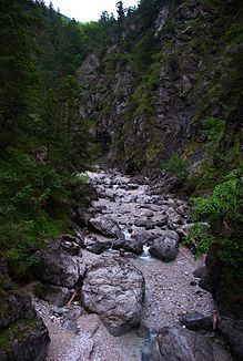
In the headwaters the brook is covered by detrital and almost invisible. This point is called "Vomper Loch" (=Hole of Vomp). Then it flows through a narrow ravine to Vomp. From the ravine to the mouth the water quality remains constant Grade A and provides the village with drinking water.
Dangers
One should not be deceived by the detrital. Below is water and the whole mass can quickly get into slippering. The water is rapid until the mouth as a typical rapid-river brook.
References
Vomperbach Wikipedia(Text) CC BY-SA