
Archipelago South Sandwich Islands Highest elevation 1,005 m (3,297 ft) Area 35 km² | Width 4.8 km (2.98 mi) Highest point Mount Hodson Max length 11.6 km Island group South Sandwich Islands | |
 | ||
Similar | ||
Breaking 6 7 earthquake tsunami warnings visokoi island
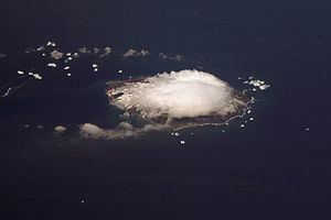
Visokoi Island is an uninhabited island in the Traversay Islands group of the South Sandwich Islands. It was discovered in 1819 by a Russian expedition under Fabian Gottlieb von Bellingshausen, who named the island Visokoi ("high") because of its conspicuous height.
Contents
- Breaking 6 7 earthquake tsunami warnings visokoi island
- Map of Visokoi Island SIQQ 1ZZ South Georgia and the South Sandwich Islands
- Mega quake 6 9 visokoi island 6 2 japan 5 2 new mexico
- References
Map of Visokoi Island, SIQQ 1ZZ, South Georgia and the South Sandwich Islands
The island is 7.2 km (4.5 miles) long and 4.8 km (3.0 miles) wide, capped by Mount Hodson, a volcanic peak (1,005 metres or 3,297 feet). The peak is named after Sir Arnold Weinholt Hodson, a governor of the Falkland Islands.
The island's eastern tip, Irving Point, is named for the commander of a British exploratory and mapping expedition, John J. Irving.
Mega quake 6 9 visokoi island 6 2 japan 5 2 new mexico
References
Visokoi Island Wikipedia(Text) CC BY-SA