
Existed: 1933 – present Constructed 1933 | Length 36.2 km | |
 | ||
Counties Pittsylvania County, Virginia, Danville | ||
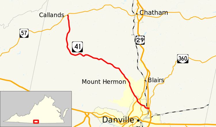
State Route 41 (SR 41) is a primary state highway in the U.S. state of Virginia. Known as Franklin Turnpike, the state highway runs 22.5 miles (36.2 km) from SR 360 northeast of Danville to SR 57 in Callands. The Virginia Department of Transportation (VDOT) officially designates the route north of U.S. Route 29 Bus. in Danville as a part of SR 41 but the Franklin Turnpike south and east of this point is signed as SR 41.
Contents
Map of VA-41, Virginia, USA
Route description
SR 41 begins at a stop-controlled T-intersection with SR 360 (Old Richmond Road) in an unincorporated area of Pittsylvania County. The route starts as a four-lane divided highway and within 0.2 miles (0.32 km) of its southern terminus, it has an interchange with the US 29 freeway. After the interchange, SR 41 crosses over Falls Creek and a railroad on a 640-foot-long (200 m), curved bridge. While traveling over the bridge, the route enters the city limits of Danville. The route has only a few driveways and one road intersection before its intersection with SR 293 (Main Street). The highway then heads northwest through a more residential neighborhood and intersects US 29 Bus. (Piney Forest Road) before leaving the independent city and reentering Pittsylvania County. SR 41 passes through the unincorporated communities of Mount Hermon and Pleasant Gap, where the highway crosses White Oak Mountain. The state highway curves west then veers north at Swansonville. SR 41 reaches its northern terminus at SR 57 (Callands Road) in Callands. The state highway follows the height of land north of the watershed of the Sandy River, which empties into the Dan River in Danville. To the north of SR 41 are the watersheds of Little Falls Creek east of White Oak Mountain and the Bannister River west of the mountain; these streams empty into the Dan River at Danville and near South Boston, respectively.
History
SR 41 was previously designated as a road in the vicinity of Charles City, Richmond, and Keswick from June 1923 until the middle of 1933.
By 1933, SR 41 designated on the former SR 301 between Danville at what was then US 29 (Main Street) and SR 108 in Franklin County. The route was truncated to its present northern terminus at SR 57 in 1949 due to low traffic counts on the segment between SR 57 and SR 108. In August 1962, the Commonwealth Transportation Board (CTB) approved a motion to drop the 0.92-mile-long (1.48 km) segment of SR 41 between North Main Street (US 29) and Piney Forest Road (what was then Alt. US 29) at the same time major highways were constructed throughout downtown Danville. Despite this truncation, the route continued to be signed to North Main Street.
In 2001, the Franklin Turnpike Extension was approved by the CTB to be constructed. Initially, the new road was designated SR 265. The portion of the extension from the US 29 interchange to SR 360 had already been completed when construction on the remainder of the extension began. The project (later renamed to East Franklin Turnpike and renumbered to be a part of SR 41) was completed in late 2011 at a cost of US$19,000,000.