
Existed: early 1980s – present | North end: SR 420 in Alexandria Length 4.2 km | |
 | ||
South end: SR 613 at south city limit of Alexandria | ||
State Route 401 (SR 401) is a primary state highway in the U.S. state of Virginia. Known as Van Dorn Street, the state highway runs 2.61 miles (4.20 km) from SR 613 at the south city limit of the independent city of Alexandria north to SR 420 within Alexandria.
Contents
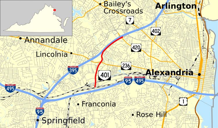
Map of VA-401, Alexandria, VA, USA
Route description
SR 401 begins at the south city limit of Alexandria, which is located on the north side of the underpass of CSX's RF&P Subdivision. Van Dorn Street continues south as SR 613 into Fairfax County toward its interchange with the Capital Beltway (Interstate 95 and I-495) and Franconia. SR 401, which heads north as a four-lane divided highway, has an intersection with Eisenhower Avenue, an east–west arterial through the industrial southern edge of Alexandria, and has a trumpet interchange with a connector to Eisenhower Avenue and the Van Dorn Street station on the Washington Metro's Blue Line. There is no ramp from the connector to northbound SR 401. The state highway crosses over Norfolk Southern Railway's Washington to Atlanta Main Line and Backlick Run and intersects Edsall Road.
SR 401 continues through a partial cloverleaf interchange with SR 236 (Duke Street) adjacent to Landmark Mall. North of the mall, the state highway becomes an undivided highway, crosses Holmes Run, and begins to closely parallel I-395 (Henry G. Shirley Memorial Highway). SR 401 continues northeast to a point within SR 420's (Seminary Road) overpass of the highway and the latter highway's three-level diamond interchange with I-395. Van Dorn Street continues northeast as an unnumbered street to its end at SR 7 on the boundary between Alexandria and Arlington. Access from Van Dorn Street to SR 420 is provided by a pair of intersections with Kenmore Avenue that lead to a pair of right-in/right-out intersections with the overpassing highway.
History
SR 401 was assigned to its present location, previously unnumbered, in the early 1980s, but it only ran as far north as SR 236. In the mid-1980s, it was extended to its current terminus at SR 420. Its current route was once part of Fairfax County, and the portion of SR 401 from immediately south of Edsall Road to its southern terminus was part of SR 613 until it was annexed by Alexandria in the 1950s.
Major intersections
The entire route is in Alexandria.