
Existed: by 1939 – present | Length 57.66 km | |
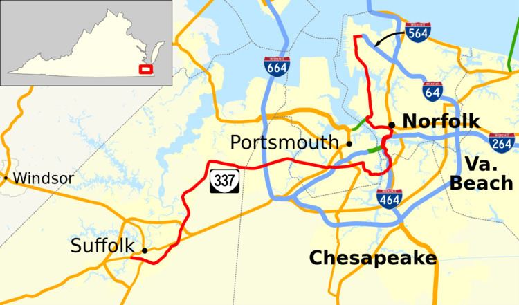 | ||
State Route 337 (SR 337) is a primary state highway in the South Hampton Roads area of the U.S. state of Virginia. It runs east from Suffolk to Portsmouth, where it crosses Jordan Bridge. It continues on the east side of the Southern Branch Elizabeth River in the South Norfolk neighborhood of Chesapeake. There it turns north, through Norfolk, crossing the Berkley Bridge into downtown, and ending at the Naval Station Norfolk at Sewell's Point. Most of its length was formed when other highways were rerouted: U.S. Route 460 from Suffolk to South Norfolk, SR 170 (now SR 168) from South Norfolk to downtown Norfolk, and US 17 from downtown Norfolk to Sewell's Point (the former location of the Newport News Ferry). SR 337 is the only numbered highway to cross all three Branches of the Elizabeth River. It crosses the Western Branch as Portsmouth Boulevard at the Hodges Ferry Bridge, the Southern Branch on the Jordan Bridge, and the Eastern Branch on the Berkley Bridge. The Berkley Bridge is a drawbridge. SR 337 also crosses the Lafayette River in the city of Norfolk.
Contents
Map of VA-337, Virginia, USA
Route description
SR 337 begins at U.S. Route 58 Business west of downtown Suffolk and ends at the north end of Interstate 564 at Naval Station Norfolk. It uses a number of different streets to get there. Through downtown Suffolk, SR 337 is Washington Street. This becomes Nansemond Parkway after crossing US 58 Bus. at Magnolia, and becomes Portsmouth Boulevard as it enters Chesapeake. The name remains after it enters Portsmouth via the Hodges Ferry Bridge, including a short concurrency with US 460 Alt. between US 58 and I-264, until the Elm Avenue intersection. There SR 337 turns south on Elm Avenue, which turns east to reach the Jordan Bridge. At the Jordan Bridge, SR 337 again enters Chesapeake, heading east on Poindexter Street across I-464 and north on Bainbridge Boulevard. (US 460 and SR 166 use the other two legs of the Poindexter-Bainbridge intersection.)
Bainbridge Boulevard takes SR 337 into Norfolk, where it makes several turns onto Main Street, Liberty Street, State Street, and Berkeley Avenue to join I-464, quickly merging into I-464 (and US 460 Alt.) over the Berkley Bridge. SR 337 leaves I-264 in downtown Norfolk to head north on Tidewater Drive. (US 460 Alt. also leaves there, but onto St. Pauls Boulevard.) SR 337 turns west at Brambleton Avenue, joining US 460 for a short while before it turns onto St. Pauls Boulevard. Between Boush Street and the Midtown Tunnel interchange, SR 337 is concurrent with US 58; US 58 runs into the tunnel while SR 337 turns north there onto Hampton Boulevard. Inside the Naval Station Norfolk, SR 337 turns east on Admiral Taussig Boulevard to end at the beginning of I-564, where Taussig Boulevard becomes a freeway.
Alternate routes
There are three routes known as State Route 337 Alternate, one in Portsmouth, one in downtown Norfolk, and one along US 460 in South Norfolk and Norfolk. The Portsmouth route does not return to SR 337 at its east end.
The 1.09 miles (1.75 km) downtown Norfolk route uses Waterside Drive and Boush Street between the Berkley Bridge (SR 337/I-264/US 460 Alt.) and Brambleton Avenue (SR 337/US 58). The route runs by major attractions such as Waterside Marketplace, Town Point Park, and Nauticus. Waterside Drive was built in order to revive the Downtown area. According to the traffic counts, southbound traffic uses Duke Street from Brambleton Avenue south to Tazewell Street, but the one-way pair no longer exists, as Norfolk has made Boush Street two-way.
History
By 1939, SR 337 existed along 21st Street and Hampton Boulevard from Granby Street (part of State Route 27, State Route 170 after 1940) near downtown Norfolk north to the Newport News Ferry at Sewell's Point. This route and its extension to downtown, using Hampton Boulevard, 21st Street, Granby Street, Princess Anne Road, Bank Street, Main Street, and Commercial Place to the Portsmouth Ferry in downtown Norfolk, had been designated as a state highway in 1932, to be maintained by Norfolk with aid from Virginia under Chapter 415, Acts of 1932. It was initially part of US 17, but in the early 1930s US 17 was rerouted west of Norfolk via the James River Bridge, bypassing both ferries. The part south of 21st Street and Granby Street was still SR 27, but the rest became SR 337 (or was unnumbered for several years).
In 1942 or 1943, US 460 was moved onto its current alignment between downtown Suffolk and South Norfolk, using US 58, the Norfolk Bypass (State Route 13, now US 13), and former SR 170 (moved then to a more easterly alignment between Great Bridge and downtown Norfolk). The part of former US 460 from Main Street and Washington Street in downtown Suffolk to Park Avenue and Bainbridge Boulevard in South Norfolk became an extension of SR 337. In South Norfolk, SR 337 then followed US 460 and former SR 170 north on Bainbridge Boulevard and northeast on Poindexter Street. US 460 continued northeast on Wilson Road, but SR 337 replaced SR 170 northwest on Liberty Street into Norfolk and north on Main Street over the old Berkley Bridge. In downtown Norfolk, it continued along former SR 170 on Main Street and Bank Street, merging with SR 170 at Brambleton Avenue. The routes continued together along Bank Street, Princess Anne Road, and Granby Street to the former south end of SR 337 (21st Street).
An alternate route was formed in 1947 in South Norfolk and Norfolk by request of those two cities. The route was completely locally maintained, receiving none of the state funds that were typically assigned to numbered routes in cities. It began at the intersection of Bainbridge Boulevard and Poindexter Street, and traveled north on Bainbridge Boulevard and northeast on Main Street to end at Liberty Street. This alternate became the main route in 1953, with a corresponding transfer in state funding. The portion of Liberty Street between Poindexter Street and Main Street thus became unnumbered, while the piece of Poindexter Street that had carried SR 337 continued to carry US 460. However, at the same time, a new alternate route was created, entirely concurrent with US 460 (Poindexter Street, Wilson Road, Campostella Road, and Brambleton Avenue) between Bainbridge Boulevard in South Norfolk and Bank Street in downtown Norfolk. It was eliminated by 1957.
When the Berkley Bridge replacement was being planned, it was temporarily assigned the State Route 337 Alternate designation in 1951, pending the completion of the "Norfolk Traffic Study". The bridge opened in 1952, and in 1953 SR 337 was rerouted to use it. The new alignment began at the intersection of Main and Liberty Streets and used Liberty and State Streets to reach the bridge. On the downtown side it exited onto City Hall Avenue, rejoining the former SR 337 at Bank Street. Part of the former SR 337 was deleted, but US 58 continued to use Main Street between Commercial Place (the Portsmouth Ferry approach) and the north end of the old Berkley Bridge until the Downtown Tunnel opened. Southbound traffic, at least after the tunnel opened, used Liberty Street from the south end of the bridge to State Street.
Also in 1953, the new US 58 bypass of downtown Suffolk (now US 58 Bus.) was completed. US 58 was rerouted onto the bypass, and SR 337 was extended west from Main Street in downtown Suffolk (where US 58 had previously turned) along Washington Street to the west end of the bypass, where it continues to end today.
In 1957, once the relocation of Bank Street (now St. Pauls Boulevard) and reconstruction of Monticello Avenue north of Brambleton Avenue was completed, the numbered routes in Norfolk were modified. Coming off the bridge into downtown Norfolk, SR 337 instead turned east at City Hall Avenue, running onto Tidewater Drive along with US 58. At Virginia Beach Boulevard, where US 58 turned east, SR 337 turned west, turning north on Monticello Avenue (US 460) and west on 21st Street to rejoin its former route.
In 1962, SR 337 was rerouted off 21st Street to use the rebuilt Brambleton Avenue. It turned off Tidewater Drive at Brambleton (there US 460), running west and northwest to the new Midtown Tunnel interchange. It turned north there onto Hampton Boulevard, rejoining the old route at 21st Street. 21st Street was dropped from the state highway system; the piece of Virginia Beach Boulevard that had been used by SR 337 was reassigned to US 58, which ran concurrent with the new SR 337 between Bank Street (St. Pauls Boulevard) and the Midtown Tunnel.
The final changes in the alignment of SR 337 were caused by Interstate Highways. I-564 replaced part of SR 170, which had shared a terminus with SR 337 at the Naval Air Station Norfolk, in 1979. The northern section, from the end of I-564 along Admiral Taussig Boulevard to SR 337, became an extension of SR 337. In the late 1980s, I-464 was completed to I-264 between the Downtown Tunnel and Berkley Bridge, resulting in a reconfiguration of the interchange where SR 337 had joined I-264 to cross the bridge. Both bridge ramps now serve Berkley Avenue, which SR 337 now uses to get between the bridge and State Street. A direct connection was also built at that time from the Jordan Bridge to the intersection of Bainbridge Boulevard and Poindexter Street, in conjunction with a full interchange at I-464. The section on Park Avenue was removed, along with the concurrency with US 460 and SR 166, in favor of the direct connection.
The original Jordan Bridge closed on November 8, 2008 and was reopened as the South Norfolk Jordan Bridge in October 2012.
Hodges Ferry Bridge
Hodges Ferry Bridge is the named bridge that carries State Route 337 across the Western Branch of the Elizabeth River in the Independent city of Chesapeake in the South Hampton Roads region of southeastern Virginia.
At the point it crosses the Western Branch, Route 337 is also named Portsmouth Boulevard.