
Length 9.12 km | ||
 | ||
North end: I‑264 / US 460 / SR 337 in Norfolk | ||
Interstate 264 downtown tunnel and interstate 464
Interstate 464 (I-464) is an Interstate Highway in the U.S. state of Virginia. The highway runs 5.67 miles (9.12 km) from U.S. Route 17 (US 17) and Virginia State Route 168 (SR 168) in Chesapeake north to I-264 in Norfolk. I-464 connects two major highway junctions in the South Hampton Roads region. At its southern end, the Interstate meets two major highways that head toward North Carolina, US 17 and SR 168, and I-64, which follows the southern side of the Hampton Roads Beltway. At its northern terminus, I-464 has connections with Downtown Norfolk and Portsmouth via I-264.
Contents
- Interstate 264 downtown tunnel and interstate 464
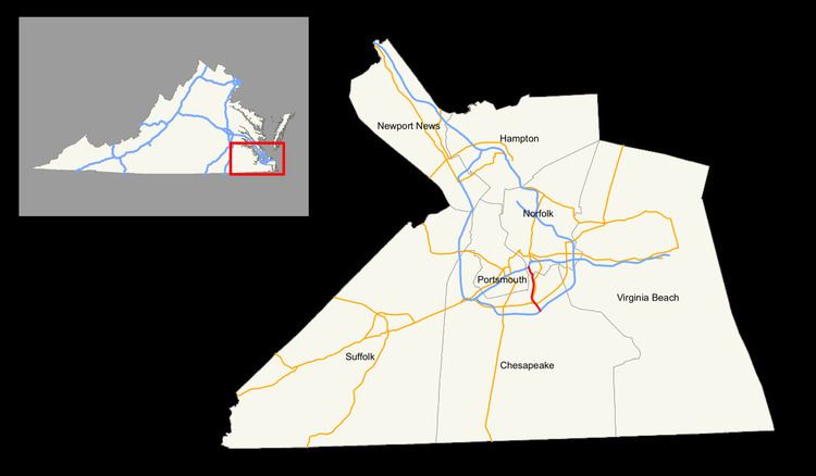
- Map of I 464 Virginia USA
- Route description
- References
Map of I-464, Virginia, USA
Route description
I-464 begins in the city of Chesapeake at the northern end of the directional interchange between US 17 (Dominion Boulevard) and SR 168 (Oak Grove Connector). US 17 heads south toward the Inner Banks community of Elizabeth City. SR 168 heads south toward the Outer Banks, including Nags Head and Manteo. Just north of I-464's terminus is a cloverleaf interchange with I-64 (Hampton Roads Beltway), between which US 17 and SR 168 run concurrently with northbound and southbound I-464, respectively. US 17 and SR 168 join I-64 for their own short concurrencies, with US 17 heading west toward Suffolk and SR 168 heading east toward Virginia Beach. I-464 heads north as a six-lane freeway that meets US 13 (Military Highway) at a diamond interchange and crosses over Norfolk Southern Railway's Norfolk District.
I-464 passes over US 460 and SR 166 (Bainbridge Boulevard) with no access; the connection is made indirectly through a diamond interchange with Freeman Avenue, which serves one of the industrial areas along the Southern Branch Elizabeth River. The Interstate parallels Bainbridge Boulevard north to a cloverleaf interchange with SR 337 (Poindexter Street), which leads to the recently-replaced South Norfolk Jordan Bridge which provides alternate access to Portsmouth. I-464 crosses over another Norfolk Southern rail line at the boundary between Chesapeake and Norfolk and has a partial interchange with South Main Street before reaching its northern terminus at a directional interchange with I-264 in the Berkley neighborhood of Norfolk. The ramp from northbound I-464 to westbound I-264, which passes through a trench, also provides access to State Street and Berkley Avenue. Eastbound I-264 crosses the Eastern Branch Elizabeth River on the Berkley Bridge into downtown Norfolk. Westbound I-264 passes under the Southern Branch via the Downtown Tunnel into the city of Portsmouth.