
Existed: 1933 – present Constructed 1933 | Length 241.4 km | |
 | ||
East end: US 17 Bus. / SR 14 in Gloucester | ||
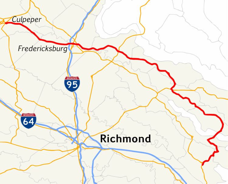
State Route 3 is a primary state highway in the U.S. state of Virginia that extends from the town of Culpeper south and eastwardly to Gloucester in Virginia's Middle Peninsula region. For many years, a portion was named "Historyland Highway".
Contents
- Map of VA 3 Virginia USA
- Gloucester County
- Mathews County
- Middlesex County
- Lancaster County
- Richmond County
- Westmoreland County
- King George County
- Stafford County
- City of Fredericksburg
- Spotsylvania County
- Orange County
- Culpeper County
- Town of Culpeper
- History
- Fredericksburg Business Route
- Warsaw Business Route
- References
Map of VA-3, Virginia, USA
Gloucester County
Route 3 begins as the John Clayton Memorial Highway in Gloucester, sharing the highway with State Route 14.
Mathews County
After entering Mathews County, Virginia, Route 3 takes a left onto Windsor Road and then a Right on Dutton Road. After that, it takes a left and crosses the Piankatank River.
Middlesex County
After crossing the Piankatank River, goes through Hartfield and Greys Point, and then crosses the Rappahannock River on the Robert O. Norris Bridge.
Lancaster County
Route 3 is called Mary Ball Road in Lancaster County, named after George Washington's mother Mary Ball Washington, who was born there. A section is the Lancaster Courthouse Historic District, including the "post village" which has long been the county seat.
Richmond County
In Richmond County, Route 3 splits into a business route and a bypass in Warsaw. The business route is concurrent with US 360 going through the town. After leaving the town, it narrows into two lanes.
Westmoreland County
Route 3 is a Scenic Byway between Montross and Oak Grove. It passes by Westmoreland State Park and the George Washington Birthplace National Monument.
King George County
The King George County segment of State Route 3 is known as King's Highway throughout the county. It traverses the county boundaries in a fairly east–west direction, starting at the King George County-Westmoreland County boundary line. It extends westward, crossing U.S. Route 301 and widening back to four lanes as it continues towards Stafford County and the city of Fredericksburg.
Kings Highway is also the main access road to Interstate 95 through Fredericksburg for King George County.
A large portion of the King George County Administration is situated on Kings Highway. The county courthouse, county seat, Sheriff's office, the offices of the Board of Supervisors and School Board are located at State Route 3 through King George County.
Stafford County
Route 3 enters the county after passing over Muddy Creek. In Stafford County, Route 3 is called Kings Highway. It passes by Ferry Farm, the boyhood home of George Washington.
City of Fredericksburg
Route 3 splits into a business route and a bypass while going through Fredericksburg. The bypass is called the Blue and Gray Parkway. The business route follows William Street. Both routes enter the city by passing over the Rappahannock River, although on different bridges. They rejoin as William Street just before the U.S. 1 interchange. The street name changes to Plank Road somewhere between Route 1 and Interstate 95.
Spotsylvania County
Route 3 is known as Plank Road in Spotsylvania County. It's a divided highway of at least four lanes, sometimes six and eight, for the duration of this segment. The Spotsylvania Mall and large Central Park regional shopping center next to it, are located at the junction with Interstate 95. It is the most heavily traveled portion of Route 3.
Orange County
SR 3 slightly goes through Orange County. When entering westbound the highway intersects VA 20 at Wilderness.
Culpeper County
Route 3 is known as Germanna Highway in Culpeper County, after an early colonial community of German ironworkers.
Town of Culpeper
Route 3 enters the town of Culpeper after crossing over the U.S. Route 15/U.S. Route 29 bypass of the city. It ends at U.S. Route 15 Business at an intersection with Orange Road.
History
State Route 7 was defined as part of the original 1918 state highway system from Winchester southeast via Front Royal, and Culpeper to Fredericksburg, and then along the Northern Neck via Warsaw to Reedville. This is now approximated by U.S. Route 522, State Route 3, and U.S. Route 360.
In late 1921, the State Highway Commission looked at possible routes between Winchester and Front Royal, specifically via Middletown to Cedarville and via Boyce, White Post, Stone Bridge, and Rockland to Cedarville, and decided on the direct route via Double Toll Gate.
SR 7 at first ran from Montross via Templeman to Warsaw and then east via Heathsville to Reedville. By late 1922, a branch northwest from Callao via Hague to Templeman was added and assigned the State Route 7-X designation.
In the 1923 renumbering, SR 7 became State Route 37 (and SR 7-X became State Route 371). By the end of that year, SR 37's east end was moved from Reedville to Westland, and the old road between Warsaw and Reedville became part of SR 371.
Fredericksburg Business Route
State Route 3 Business runs through historic Fredericksburg primarily along William Street and the Kings Highway, although a one-way split of the route exists between Washington Avenue and Amelia Street.
Warsaw Business Route
State Route 3 Business in Warsaw includes Main Street and a concurrency with US 360.