
Existed: early 1970s – present Length 29.66 km | ||
 | ||
East end: SR 30 / SR 33 at Angelview Church | ||
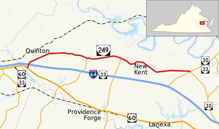
State Route 249 (SR 249) is a primary state highway in the U.S. state of Virginia. Known as New Kent Highway, the state highway runs 18.43 miles (29.66 km) from Interstate 64 (I-64) and SR 33 near Bottoms Bridge east to SR 33 and SR 30 at Angelview Church. According to signage on the segment of New Kent Highway between U.S. Route 60 and I-64, SR 249 extends slightly south from I-64 to end at US 60. SR 249, which is the old alignment of SR 33 before that highway was rerouted onto I-64, is the main local highway of northern New Kent County, providing access to the county seat of New Kent.
Contents
Map of VA-249, Virginia, USA
Route description
SR 249 begins at a partial cloverleaf interchange with I-64 and SR 33 near Bottoms Bridge at the western end of New Kent County. New Kent Highway continues south as SR 33 to that highway's junction with U.S. Route 60 though this short 0.4-mile-long (0.64 km) segment of road is also signed as SR 249. SR 249 passes through the interchange as a four-lane divided highway but reduces to two lanes as it curves east. The state highway passes through the hamlet of Quinton and meets the northern end of SR 106 (Emmaus Church Road) at a roundabout in Talleysville. East of Carps Corner, the site of the highway's junction with SR 155 (Courthouse Road), SR 249 passes through New Kent, which features the county courthouse, county offices, and the county's high school and middle school. The state highway reaches its eastern terminus at a four-way intersection with SR 30 and SR 33 at Angelview Church. SR 33 passes through the intersection as Eltham Road. SR 30 heads east concurrently with SR 33 toward West Point and southeast along a continuation of New Kent Highway toward Williamsburg.
History
The current SR 249 was assigned in the early 1970s to a portion of former State Route 33 in New Kent County. The western 11 miles (18 km) roughly follow the old Richmond-Williamsburg Stage Road, and it currently is named New Kent Highway. (The continuation east across SR 33 as State Route 632 is still named Old Stage Road.) [1] The Old Stage Road was one of two routes heavily used by both Confederate and Union troops in 1862 during the Peninsula Campaign of the American Civil War.
In the early 1970s, the new Interstate 64 was under construction east of Richmond. Although primarily following the alignment of US 60 in this area, traffic relief for other roadways was also anticipated. Nearby, SR 33 between Eltham and Quinton in New Kent County had an extraordinarily high accident rate due to heavy weekend traffic to waterfront points in eastern Virginia.
Upon partial completion, in the early 1970s, a stretch of newly built Interstate 64 was opened early (from exit 205 to exit 220) as State Route 33 in order to divert traffic off one of the most accident-prone portions of the former winding and hilly two-lane route through New Kent Courthouse, which was renumbered State Route 249. Although the Interstate Highway was not ready for the heavy traffic load which would come from the through traffic of US 60, Exit 220 provides no easy access to US 60, so the new usage could be anticipated to primarily appeal only to lower volume of the SR 33 traffic. Richmond newspapers at the time praised the move and credited Virginia's highway officials with preventing continued carnage on the old highway.
Major intersections
The entire route is in New Kent County.