
Existed: 1940 – present Length 12.47 km | Constructed 1940 | |
 | ||
Counties Newport News, York County, Virginia | ||
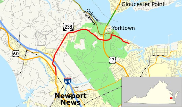
State Route 238 (SR 238) is a primary state highway in the U.S. state of Virginia. The state highway runs 7.75 miles (12.47 km) from U.S. Route 60 (US 60) in Newport News east to United States Coast Guard Training Center – Yorktown near Yorktown. SR 238 connects Interstate 64 (I-64) with Naval Weapons Station Yorktown, the Yorktown portion of Colonial National Historical Park, and the Coast Guard training center. The majority of SR 238 is part of the Washington–Rochambeau Revolutionary Route.
Contents
Map of VA-238, Virginia, USA
Route description
SR 238 begins at an oblique intersection with US 60 (Warwick Boulevard) in the Lee Hall area of the independent city of Newport News. The state highway heads north as two-lane Yorktown Road and immediately has a grade crossing of CSX's Peninsula Subdivision. SR 238 passes the Lee Hall Mansion before expanded to a four-lane divided highway through its partial diamond interchange with I-64. The interchange provides access to and from the direction of Norfolk; access to I-64 in the direction of Richmond is provided by SR 143 (Jefferson Avenue) at the next intersection. SR 238 continues north as a two-lane road whose name changes to Old Williamsburg Road on entering York County. The state highway gradually curves to the east as it follows the edge of Naval Weapons Station Yorktown, whose main entrance is in the community of Lackey.
East of Lackey, SR 238 enters Colonial National Historical Park, where the highway passes through a forested area with scattered residential subdivisions. The state highway turns southeast onto Goosley Road while Old Williamsburg Road continues to the center of Yorktown. SR 238 intersects US 17 (George Washington Memorial Highway) before turning north onto Cook Road, then east on Moore House Road within a large field that was the site of fighting in the Revolutionary War Siege of Yorktown. Moore House Road heads west into the center of Yorktown and provides access to Colonial Parkway. SR 238 follows Moore House Road parallel to the York River, then veers inland along Ballard Street while Moore House Road continues straight into a residential neighborhood. SR 238 reaches its eastern terminus just beyond Nelson Road at the entrance to United States Coast Guard Training Center – Yorktown.