
Existed: 1933 – present East end: US 50 in Arlington Constructed 1933 | Length 21.03 km East end US 50 in Arlington | |
 | ||
Counties | ||
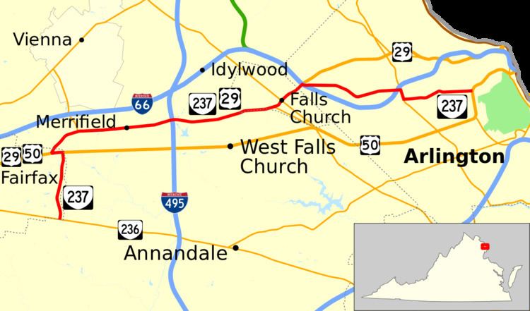
State Route 237 (SR 237) is a primary state highway in the U.S. state of Virginia. The state highway runs 13.07 miles (21.03 km) from SR 236 in Fairfax east to U.S. Route 50 (US 50) in Arlington. SR 237 connects Fairfax and Arlington with Falls Church. Between Fairfax and Falls Church, the state highway mostly runs concurrently with US 29. East of Falls Church, SR 237 parallels Interstate 66 (I-66) and connects several of Arlington's urban villages.
Contents
Map of State Rte 237, Arlington, VA 22201, USA
Route description
SR 237 begins at an intersection with SR 236 (Main Street) at the eastern edge of the city of Fairfax. The state highway heads north as Pickett Road, a four-lane divided highway that parallels the eastern boundary of the city between a pair of shopping centers, an oil depot, a country club, and a park within which the highway crosses Accotink Creek. Pickett Road ends at US 50 (Arlington Boulevard); the roadway continues north as Blake Lane while SR 237 turns west onto six-lane US 50 for the short distance to Fairfax Circle, a four-leg cut-through traffic circle through which US 50 passes as the main road. US 50 continues west along with US 29 on Lee Highway, which is also a bypass of downtown Fairfax named Fairfax Boulevard. The south leg of the junction is Old Lee Highway, which heads toward downtown Fairfax. SR 237 and US 29 follow Lee Highway on the north leg of the traffic circle. North of Fairfax Circle, the two highways exit the city of Fairfax and intersect SR 655 (Blake Lane).
SR 237 and US 29 head east along a five-lane road with center turn lane that intersects Nutley Street, which heads north as SR 243 and provides access to the Vienna station on the Orange Line of the Washington Metro and I-66 on its way to Vienna. The two highways pass through the industrial community of Merrifield. There, the road becomes a divided highway and intersects SR 650 (Gallows Road), which leads north to the Washington Metro's Dunn Loring station. SR 237 and US 29 cross over I-495 (Capital Beltway) between the Interstate's interchanges with I-66 and US 50. The two highways become Washington Street, a narrow four-lane road with occasional medians, in the city of Falls Church. SR 237 and US 29 meet the western end of SR 338 (Hillwood Avenue) next to The Falls Church and intersect SR 7 (Broad Street) in the center of the city.
SR 237 and US 29 become Lee Highway again on entering the East Falls Church area of Arlington County. Just north of the city boundary, the two highways intersect the Washington & Old Dominion Railroad Trail and diverge at their partial diamond interchange with I-66, which provides access to and from the direction of Front Royal and Washington Dulles International Airport. Westbound SR 237 crosses over I-66 and the Orange Line, which runs in I-66's median, with US 29; eastbound SR 237 crosses the Interstate and transit line on its own bridge. The two two-lane roadways come together on the north side of the Interstate as Washington Boulevard and the highway intersects Sycamore Street, which provides access to the East Falls Church station of the Washington Metro and to another partial diamond interchange that accesses I-66 to and from Washington.
SR 237 (Washington Boulevard) heads east from Sycamore Street as a two-lane road that passes through several densely populated neighborhoods in the Westover area of Arlington County. The state highway becomes four lanes just before crossing over I-66 into Ballston. SR 237 intersects SR 120 (Glebe Road); the state highway turns south on Glebe Road to run concurrently with six-lane SR 120, which has a partial diamond interchange with I-66 immediately to the north, while Washington Boulevard continues east as an unnumbered street. Two blocks to the south, SR 237 turns east onto Fairfax Drive, which continues west as an unnumbered street onto ramps to and from I-66 heading west. The four-lane divided highway passes through the center of Ballston and the adjoining Virginia Square and by each neighborhood's Washington Metro station, Ballston–MU and Virginia Square – GMU, respectively. Within Virginia Square, the highway passes the urban campus of the George Mason University School of Law.
At a four-way intersection with Kirkwood Road in Clarendon, SR 237 veers east onto 10th Street. The four-lane divided street passes along Clarendon's southern edge. After intersecting Washington Boulevard, SR 237 passes through a residential neighborhood. At the east end of that neighborhood, the highway reaches its eastern terminus at US 50 (Arlington Boulevard) just west of Fort Myer at the southern edge of the Courthouse neighborhood.