
Bus stands 4 Opened 7 June 1986 Platforms in use 1 | Structure type Surface Bicycle facilities 12 Tracks 2 | |
 | ||
Location 2001 North Sycamore StreetArlington, VA 22205 Owner Washington Metropolitan Area Transit Authority Similar West Falls Church station, Ballston–MU station, Wiehle–Reston East station, Stadium–Armory station, Dunn Loring station | ||
East Falls Church is a Washington Metro station in Arlington, Virginia on the Orange and Silver Lines.
Contents
- Map of East Falls Church Arlington VA 22205 USA
- Location
- Transit oriented development
- History
- Station layout
- References
Map of East Falls Church, Arlington, VA 22205, USA
Location
The station serves the communities of Falls Church and Arlington, Virginia and is located in the median of Interstate 66 near Lee Highway (U.S. Route 29). Service began on June 7, 1986. East Falls Church has a parking lot with 422 spaces on the Lee Highway side of the station.
Transit-oriented development
Of the six stations on the Orange Line in Arlington, East Falls Church has the least transit-oriented development. Unlike the Rosslyn-Ballston corridor, East Falls Church station is located in the median of Interstate 66, posing pedestrian access issues. Arlington County is currently considering plans to develop the site.
History
East Falls Church opened as part of the final westward extension of the Orange Line to Vienna on June 7, 1986.
The Silver Line began service in 2014, resulting in East Falls Church becoming the final transfer point before its split with the Orange Line.
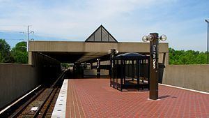
Station layout
Similar to all stations within the Interstate 66 median apart from West Falls Church, East Falls Church utilizes a simple island platform setup with two tracks. There is an exit in the central part of the platform that leads to a mezzanine on the western side of North Sycamore Street. The station's parking lot and bus bays are located to the north of this exit at the southwestern corner of the intersection of North Sycamore Street and North Washington Boulevard.