
Existed: 1933 – present Counties: Prince William Constructed 1933 | Length 54.59 km | |
 | ||
County | ||
Virginia state route 234 dumfries road from us route 1 to manassas part i
State Route 234 (SR 234) is a primary state highway in the U.S. state of Virginia. It runs from U.S. Route 1 near Dumfries via Independent Hill, a bypass of Manassas, and Catharpin to U.S. Route 15 near Woolsey.
Contents
- Virginia state route 234 dumfries road from us route 1 to manassas part i
- Map of VA 234 Virginia USA
- Route description
- History
- Recent construction
- Route 234 Business Manassas
- Old Route 234 Independent Hill
- References
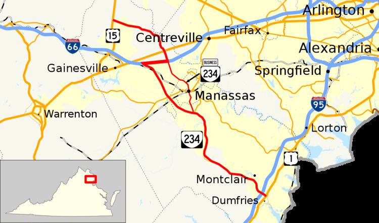
Map of VA-234, Virginia, USA
SR 234 has a brief overlap with Interstate 66 for three miles (5 km) between SR 234 south (Prince William Parkway) and SR 234 north/State Route 234 Business in Manassas.
Route description
SR 234 begins at an intersection with US 1 (Jefferson Davis Highway) on the northern edge of the town of Dumfries. The state highway heads northwest as Dumfries Road, a six-lane divided highway that meets I-95 at a partial cloverleaf interchange. North of Dumfries, SR 234 parallels Quantico Creek and follows the border of Prince William Forest Park to the southwest. The state highway also passes many residential subdivisions on the highway's northbound side in the community of Montclair, where the highway reduces to four lanes at Country Club Drive. SR 234 curves to the north at Independent Hill, which the highway bypasses. The old alignment through the village, which contains the remains of the Greenwood Gold Mine, is designated SR 234 Old. SR 234 passes through the communities of Canova, Cornwell, and Lake Jackson, where the highway crosses the Occoquan River just east of the community's namesake reservoir. Just north of Lake Jackson, the state highway intersects Prince William Parkway (SR 294), which connects Manassas and Woodbridge.
Just north of Prince William Parkway, Dumfries Road turns north toward the city of Manassas as SR 234 Business. SR 234 continues northwest as Prince William Parkway, a four-lane divided highway western bypass of Manassas. The state highway passes to the east of Manassas Regional Airport, which is accessed via Clover Hill Road. Just north of the airport, SR 234 crosses over Norfolk Southern Railway's Washington District rail line, which is also used by Virginia Railway Express's Manassas Line, whose western terminus is at the Broad Run/Airport just to the west in the community of Bristow. Just north of the rail line, the state highway meets SR 28 (Nokesville Road) at a three-level interchange featuring flyover ramps from both directions of SR 28 to SR 234. SR 234 continues north past the Prince William Campus of George Mason University, which features the Hylton Performing Arts Center, then intersects SR 674 (Wellington Road) and Sudley Manor Drive, which connects Linton Hall to the southwest with Bull Run to the northeast. SR 234 continues northwest, intersecting Balls Ford Road before reaching a trumpet interchange with I-66. SR 234 joins the Interstate in a concurrency east to a partial cloverleaf interchange with Sudley Road, where SR 234 leaves the concurrency and meets the northern end of SR 234 Business.
SR 234 heads north from I-66 as a four-lane divided highway that reduces to two lanes at the entrance to the Manassas Campus of Northern Virginia Community College and enters Manassas National Battlefield Park, site of the First and Second Battles of Bull Run. The state highway intersects US 29 (Lee Highway) within the battlefield park. After leaving the preserve, SR 234 passes through the community of Sudley Springs, where the highway crosses Little Bull Run and curves to the west. The state highway heads through the community of Catharpin before reaching its northern terminus at US 15 (James Madison Highway) in the hamlet of Woolsey north of Haymarket.
History
Most of SR 234 southeast of Manassas, for 15.85 miles (25.51 km) from State Route 28 in Manassas towards State Route 31 (U.S. Route 1) at Dumfries, was added to the state highway system in 1928 as State Route 709. The final 2.50 miles (4.02 km) were added in 1929, making SR 709 a continuous Manassas-Dumfries route.
In the other direction, from Manassas northwest towards Gilberts Corner, 6.42 miles (10.33 km) were added in 1930 and 1931. In 1932, the rest of the road to Gilberts Corner, now State Route 705 and U.S. Route 15 north of Catharpin, was added to the state highway system.
SR 709 became State Route 234 in the 1933 renumbering, as did State Route 721 (Brunswick, Maryland to south of Purcellville, now State Route 287 and part of State Route 690). The gap from U.S. Route 50 at Aldie (west of Gilberts Corner) northwest to Philomont on State Route 734 and then north towards Purcellville on SR 690 was never filled.
In the 1940 renumbering, the northern piece of SR 234 (through Purcellville) became part of State Route 17. SR 234 was rerouted to continue northwest on SR 734 from Philomont to Bluemont (also never transferred to the primary system), where it absorbed the short State Route 245 to State Route 7. At the same time, a short piece of SR 234 south of Gilberts Corner also became U.S. Route 15. Also around that time, SR 234 was rerouted to head west rather than northwest from Catharpin, using a longer piece of new US 15 (from Woolsey north to Gilberts Corner). The piece at Bluemont was transferred to the secondary system in 1943, truncating SR 234 back to Gilberts Corner and beyond to its current end at US 15.
In 2005, the Commonwealth of Virginia designated Route 234 between U.S. Route 1 and Interstate 66 as the Ronald Wilson Reagan Memorial Highway.
Recent construction
The 2005 widening of SR 234 to four lanes in the areas of Independent Hill and Canova have resulted in some minor realignments. A former stretch of SR 234 through Canova has been renamed Canova Drive, and SR 234 was moved about 1 block east. At Independent Hill, Bristow Road has been extended onto former SR 234, and SR 234 itself was realigned about 300 meters north.
During the late 1990s the SR 234 Bypass was constructed to route through traffic from I-66 to the southeast around downtown Manassas. The existing portion of SR 234 was renamed SR 234 Business.
A completed portion of the bypass was used prior to it being open to traffic as a scene in the 1998 disaster film, Deep Impact. About 2,100 extras and 1,870 vehicles were used to stage the traffic jam scene for that film.
Future construction will extend Route 234 from its current southern terminus at U.S. Route 1 through the communities of Southbridge and Harbor Station down to the Potomac River. A separated grade interchange will facilitate traffic through the intersection between Route 234 and U.S. 1. There is a proposal currently being considered by the Virginia Department of Transportation (VDOT) for the Tri-County Parkway that would include extending SR 234 (the "Manassas Bypass") along Pageland Road to Catharpin where it would meet up with the present SR 234 . This would have the effect of making the portion of SR 234 between Pageland Road and I-66 part of SR 234 Business.
Route 234 Business (Manassas)
State Route 234 Business (SR 234 Bus. or 234-BR on some maps) in Manassas is a bannered primary state highway in the U.S. state of Virginia, and traverses both Prince William County and the City of Manassas. SR 234 Business is known by three names: Dumfries Road in Prince William County and Manassas, Grant Avenue in the City of Manassas, and Sudley Road in the City of Manassas and Prince William County.
SR 234 Business starts in the south as Dumfries Road as a four lane undivided highway. As it passes by the Prince William County fairgrounds before it enters the City of Manassas, it becomes two lanes. After entering the city, Dumfries Road passes by residential neighborhoods and becomes a four-lane divided road, and crosses Wellington Road. At Wellington Road SR 234 Business changes to Grant Avenue, which is a four lane undivided highway that passes by a townhouse development (Georgetown South) and retail developments before entering Old Town Manassas and crossing over SR 28. Shortly after this point Grant Avenue reduces to two lanes, then divides into a boulevard with spaces for on-street parking, and passes by homes, some of which are antebellum in architecture.
When Grant Avenue meets Sudley Road, SR 234 Business turns to the northwest along Sudley Road. This road is a four-lane divided highway that passes by the Manassas U.S. Post Office, the Prince William Hospital (part of the Prince William Health System), and several business establishments. SR 234 Business ends at the intersection with I-66, that also carries SR 234. SR 234 continues northward from there along Sudley Road.
SR 234 Business was first formed as part of SR 234. When the Prince William Parkway / Manassas Bypass was completed, it was numbered SR 234, and the section through Manassas was renamed SR 234 Business.
There is a proposal currently being considered by the Virginia Department of Transportation (VDOT) for the Tri-County Parkway that would include extending SR 234 (the "Manassas Bypass") along Pageland Road to Catharpin where it would meet up with the present SR 234 . This would have the effect of making the portion of SR 234 between Pageland Road and I-66 part of SR 234 Business.
Old Route 234 (Independent Hill)
Old State Route 234 (Old SR 234) in Independent Hill is secondary state highway in the U.S. state of Virginia that traverses Prince William County. The current alignment of SR 234 near Independent Hill contains a curve that at one time was sharper than it is now. When VDOT widened SR 234 from two lanes to a four-lane divided highway, it realigned the road at the same time, leaving behind the old alignment in the form of Independent Hill Road, part of Bristow Road, and Rosita Court, posted as SR-3427 and SR-619.
Old SR 234 starts in the west at an intersection with Dumfries Road, to the northwest of Independent Hill as a two lane road called Independent Hill Road. At an intersection with SR 619, Independent Hill Road ends, the old alignment continues concurrent with SR 619 on Bristow Road. 0.58 miles (0.93 km) later, SR 619 leaves on Joplin Road heading to the southeast. Shortly thereafter is a junction with SR 646, Aden Road, which heads back toward western Prince William County. Bristow road then intersects with Rosita Court, and the old alignment follows this road until it dead-ends.