
Existed: 1933 – present Length 21.77 km North end SR 249 at Carps Corner | North end: SR 249 at Carps Corner Constructed 1933 | |
 | ||
Counties | ||
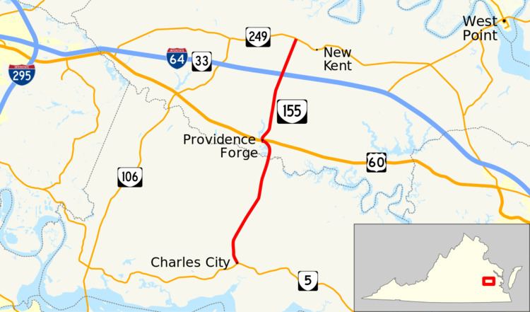
State Route 155 (SR 155) is a primary state highway in the U.S. state of Virginia. Known as Courthouse Road, the state highway runs 13.53 miles (21.77 km) from SR 5 in Charles City north to SR 249 at Carps Corner. SR 155 connects Charles City and New Kent, the county seats of Charles City County and New Kent County, respectively, with each other and with U.S. Route 60 (US 60) and Interstate 64 (I-64).
Contents
Map of VA-155, Virginia, USA
Route description
SR 155 begins at a four-way intersection with SR 5 (John Tyler Memorial Highway) in Charles City. Courthouse Road continues south as SR 644 to serve the Charles City County offices and courthouse. SR 155 heads north past Charles City Middle School and Charles City High School and passes through the hamlets of Roaches Corner and Sandybottom. The state highway crosses the Chickahominy River into New Kent County. At Providence Forge, SR 155 curves northwest through an oblique grade crossing of CSX's Peninsula Subdivision, veers west on Boulevard Road, then makes a right-angle turn north and intersects US 60 (Pocahontas Trail). The state highway intersects Kentland Trail, which leads east to several golf courses and horse-racing facility Colonial Downs, just south of its diamond interchange with I-64 and its companion SR 33. SR 155 passes to the east of the historic home Criss Cross before reaching its northern terminus at SR 249 (New Kent Highway) at Carps Corner a short distance west of New Kent.