
Length 30 km | ||
 | ||
Discharge Average rate:76.8 m/s (2,710 cu ft/s) | ||
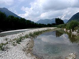
The river Vils is a 30 km long tributary of the Lech River in the Alps of Austria and Germany. The Vils has a drainage basin of approximately a 300 km², with an average annual precipitation of nearly 2000 mm.
Map of Vils, Austria
It originates in the Allgäu Alps in Tyrol from the supplies of the Vilsalpsee, and is its only discharge. Its water flows first in the northern and northwestern directions, in the Reutte district through the Vils and Tannheim valleys and here it runs alongside the B 199 road through Tannheim, Zoeblen and Schattwald. From here the Vils descends down the waterfall "Vilsfall", only slightly east/northeast of the Oberjoch Pass and only a few hundred metres east of the border to Germany. Then the river crosses the border into southern Bavaria, turns northeast and reaches the municipality Pfronten in the district Ostallgäu. Then it flows eastwards along the B 308, again crossing the border into Tyrol, flows below the Tannheimer mountains slightly south of the German border and parallel to this through the municipality Vils, and after going under the B 179 flows directly into the Lech.
With an average discharge of 76.8 cubic metres per second (2,710 cu ft/s), the Vils is among the largest rivers in Bavaria.