
Founded 14 October 1776 Area 249 km² Population 19,742 (2015) | Elevation 2,715 m (8,907 ft) Local time Monday 9:29 AM | |
 | ||
Founded by Francisco de Vargas Figueroa Weather 14°C, Wind E at 11 km/h, 64% Humidity | ||
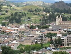
Villapinzón is a municipality and town of Colombia in the Almeidas Province, part of the department of Cundinamarca. The urban centre is situated at an altitude of 2,715 metres (8,907 ft) on the Altiplano Cundiboyacense, at a distance of 80 kilometres (50 mi) from the capital Bogotá. Villapinzón borders Ventaquemada (Boyacá) and Lenguazaque in the north, Chocontá, Tibiritá and La Capilla in the south, Chocontá and Lenguazaque in the west and Ventaquemada, Turmequé and Úmbita in the east. The municipality is located in the uppermost part of the Bogotá River Basin; the origin of the river is within the municipality Villapinzón at an altitude of 3,400 metres (11,200 ft).
Contents
Map of Villapinz%C3%B3n, Cundinamarca, Colombia
Etymology
Villapinzón was named Hato Viejo for most of its history. In 1903, the name was changed to "Pinzón", honouring Próspero Pinzón Romero, commander of the army and Minister of War of Colombia under Colombian president José Manuel Marroquín. Próspero Pinzón Romero was born in Hato Viejo. A year later, it became Villapinzón.
History
The history of Villapinzón is relatively young; historian Ramón Correa studied the pre-Columbian history of the area and did not find evidence Villapinzón was populated before the Spanish conquest of the Muisca. Villapinzón was founded on October 14, 1776 by Francisco de Vargas Figueroa.
Economy
Economically, Villapinzón is characterised by a strong chemical industry, with three major companies. Additionally, agriculture and livestock farming are important.