
State Kingdom of Denmark Highest elevation 841 m (2,759 ft) Area 41 km² Area code 298 | Area rank 7 Time zone GMT (UTC+0) Population 581 (2015) | |
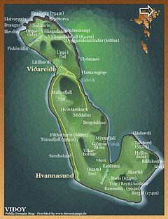 | ||
Viðoy (Danish: Viderø) is the northern-most island in the Faroe Islands, located east of Borðoy to which it is linked via a causeway. The name means wood island, despite the fact that no trees grow on the island: the name relates to the driftwood that floats in from Siberia and North America.
Contents
Map of Vidoy, Faroe Islands
Geography
The island has two settlements: Hvannasund on the south-west coast and Viðareiði on the north-west coast, the northernmost settlement in the Faroes. A road along the west coast of the island connects the two. The island is connected by a road causeway to Norðdepil on Borðoy and a bus service from Klaksvík runs across the causeway to the island.
Important bird area
The island’s northern and eastern coast has been identified as an Important Bird Area by BirdLife International because of its significance as a breeding site for seabirds, especially European storm petrels (500 pairs), black-legged kittiwakes (5300 pairs), Atlantic puffins (25,000 pairs), common guillemots (6700 individuals) and black guillemots (200 pairs).
Mountains
Viðoy has eleven mountains of which Villingadalsfjall is the northern-most peak in the Faroes. The north coast also has the Enniberg cliff, which at 750 m is the second highest sea-cliff in Europe (after Hornelen, in Norway). The mountains are shown with their overall rank in the Faroe Islands.