
Time zone GMT (UTC+0) Area 17 km² | Constituency South Constituency County Vestmannaeyjar Post code IS-900, 902 Mayor Elliði Vignisson (2006–) | |
 | ||
Islands Points of interest | ||
Unique iceland vestmannaeyjar westman islands
Vestmannaeyjar ([ˈvɛstmanːaˌeiːjar], sometimes anglicized as Westman Islands) is a town and archipelago off the south coast of Iceland.
Contents
- Unique iceland vestmannaeyjar westman islands
- Map of Vestmannaeyjar Iceland
- Compilation ferry to vestmannaeyjar westman islands iceland
- Geography
- Biodiversity
- Climate
- References
Map of Vestmannaeyjar, Iceland
The largest island, Heimaey, has a population of 4,135. The other islands are uninhabited, although six have single hunting cabins. Vestmannaeyjar came to international attention in 1973 with the eruption of Eldfell volcano, which destroyed many buildings and forced a months-long evacuation of the entire population to mainland Iceland. Approximately one fifth of the town was destroyed before the lava flow was halted by application of 6.8 billion litres of cold sea water.
Compilation ferry to vestmannaeyjar westman islands iceland
Geography
The Vestmannaeyjar archipelago is young in geological terms. The islands lie in the Southern Icelandic Volcanic Zone and have been formed by eruptions over the past 10,000–12,000 years. The volcanic system consists of 70–80 volcanoes both above and below the sea.
Vestmannaeyjar comprises the following islands:
Total: 16.3 square kilometres (6.3 sq mi)
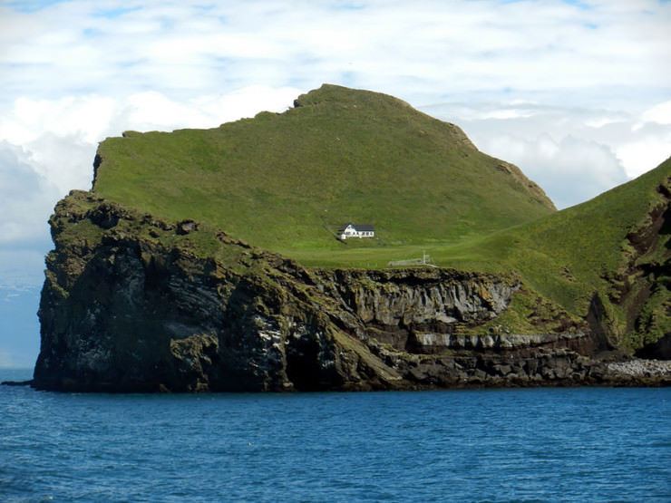
There are 15 islands, and about 30 rock stacks and skerries. All the islands have been built up in submarine eruptions and consist of alternating layers of palagonite tuff and lava. The oldest geological formations are in the northern part of Heimaey ("Home Island"), the largest island and the only inhabited one. Basalt columns can be seen in many places, and the sea has eroded the soft rock of the shoreline and scooped out many picturesque coves and grottos, which are among the special features of the islands.
There was a submarine eruption southeast of Hellisey in 1896. The next eruption began on 14 November 1963. It lasted about four years – one of the longest in Icelandic history – and gave birth to Surtsey, the 15th island in the group. In the eruption of 1973 that lasted for 155 days, Heimaey grew by about 2.1 square kilometres (0.81 sq mi). The Vestmannaeyjar group is about 38 kilometres (24 mi) long and 29 kilometres (18 mi) broad, the closest point lying about 8 kilometres (5 mi) from the mainland.
Biodiversity
There is generally very little snow, but a lot of rain. Owing to this microclimate, returning migrant birds are often first seen in the spring and they set out from the islands in the autumn. All of Iceland's seabirds can be found in Vestmannaeyjar: the guillemot, gannet, kittiwake, Iceland gull, and puffin. The puffin is the most plentiful species and is the Vestmannaeyjar emblem. More than 30 species of birds nest in their millions in the cliffs and grassy ledges, and other species make irregular appearances.
There are about 150 plant species in the flora of the islands, and about 80 types of insect have been identified. The waters around the Vestmannaeyjar contain some of the North Atlantic's richest fishing grounds. The two main commercially exploited species in Iceland, cod and haddock, are found in abundance in Vestmannaeyjar. Other species, such as flat-fish, herring and capelin, are also commonly harvested as they migrate through the area in the autumn and winter. Lobsters and ocean perch are found in large numbers in the deep water to the southeast of the islands. Seals, small types of whale and other marine species are also present in large numbers around the islands.
Climate
With extremely high precipitation considering the latitude, Vestmannaeyjar previously featured an ET Tundra climate that lately has transitioned into a subpolar oceanic climate (Cfc) under the Köppen climate classification. It is often very windy in the islands, and the highest wind speed measured in Iceland (61 metres per second;140 mph) was recorded in Stórhöfði. The main wind directions are easterly and south-easterly. The islands enjoy the country's highest average annual temperature, the Gulf Stream having a strong warming effect, especially in winter.