
Length 6.846 km | ||
 | ||
County | ||
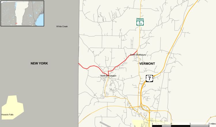
Vermont Route 67 is an east–west state highway in Bennington County, Vermont, United States. It runs from the New York state line in Shaftsbury to VT 7A farther east in the town. VT 67 also passes through the village of North Bennington.
Contents
- Map of VT 67 Shaftsbury VT 05262 USA
- Route description
- History
- Major intersections
- Vermont Route 67A
- Vermont Route 67A Connector
- References
Map of VT-67, Shaftsbury, VT 05262, USA
Route description
VT 67 starts at the New York state line as an eastward continuation of New York State Route 67. It curves twice, intersecting with White Creek Road, a continuation of Washington County, New York, County Route 68.
In North Bennington, VT 67 meets the northern terminus of VT 67A. As it does so, it curves straight north, with a secondary street (Houghton Street) leading to Lake Paran. After the intersection with Hawks Avenue, it takes a northeasterly path, ending at VT 7A in Shaftsbury.
History
VT 67 was assigned by 1935, when it was added to the Vermont state highway system as part of the 1935 state highway system expansion.
Major intersections
The entire route is in Bennington County.
Vermont Route 67A
Vermont Route 67A is a north–south state highway in Bennington County. It extends for 3.348 miles (5.388 km) from VT 7A in Bennington to VT 67 in North Bennington. VT 67A connects to VT 279 via an interchange located roughly 0.43 miles (0.69 km) north of VT 7A.
Vermont Route 67A Connector
Vermont Route 67A Connector was a connector route of VT 67A in Bennington. It was a short limited-access highway linking VT 67A to U.S. Route 7. VT 67A Connector was assigned in 1974 and removed in 2004 concurrent to the assignment of VT 279.