
Length 36.17 km | ||
 | ||
Major cities | ||
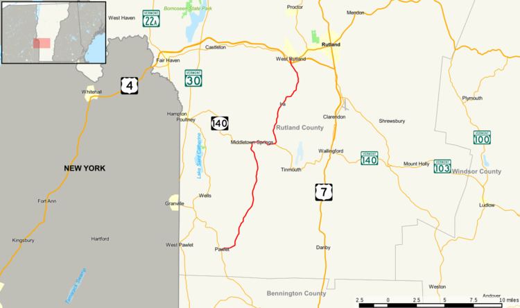
Vermont Route 133 is a 22.476-mile (36.172 km) north–south state highway in Rutland County, Vermont, United States. It runs from Pawlet in the south to West Rutland in the north.
Contents
Map of VT-133, Vermont, USA
Route description
VT 133 begins at an intersection with VT 30 in the Rutland County town of Pawlet. Running eastward along Danby–Pawlet Road, VT 133 parallels the Flower Brook through a residential stretch. Turning northeast, the route soon turns north off Danby–Pawlet Road and run north through the rural areas of Pawlet. VT 133 soon begins to wind northeast through Pawlet, soon crossing into the town of Tinmouth, bending north and bypassing the hamlet of East Wells. Running along the side of a ridge, VT 133 becomes West Tinmouth Road, soon reaching Middletown Springs.
VT 133 becomes known as South Street as it enters Middletown Springs, winding through fields and nearby golf courses, making a short northwestern turn near Daisy Hollow Road. As it enters the center of Middletown Springs, VT 133 bends northeast, becoming the main north–south street through the community, a two-lane residential street. Crossing the Poultney River, the route enters downtown Middletown Springs, reaching a junction with VT 140 (West Street). VT 133 and VT 140 run concurrent on East Street, running through Middletown Springs. The routes soon leave downtown Middletown Springs, paralleling the Poultney River, along East Street.
VT 133 and VT 140 run east for a distance, soon bending southeast, changing names to Morgan Road when the routes re-enter the town of Tinmouth. In Tinmouth, VT 133 forks northeast on Morgan Road while VT 140 runs southeast from there. Making a gradual curve to the north, VT 133 leaves the town of Tinmouth for the town of Ira, remaining a two-lane rural roadway. Through Ira, the route does sporadically cross through dense woods, turning northeast through the fields in town. VT 133 passes the residential "center" of Ira, a small hamlet along the road, consisting of a short eastern turn until Weaver Hill Road.
VT 133 runs northeast through Ira, soon crossing into the town of Clarendon. The route junctions with Walker Mountain Road, where it gains the moniker of Clarendon Road. Paralleling the Clarendon River, VT 133 reaches West Rutland, where it changes names to Clarendon Avenue. Through West Rutland, VT 133 runs northwest, becoming a main residential street through town. At Fox Run Lane, the route bends northward, crossing under US 4 just west of exit 6. After US 4, VT 133 turns north for three blocks, reaching a junction with VT 4A (Main Street).
Major intersections
The entire route is in Rutland County.