
- Town privileges 1408 Area 40.66 km² | Elevation 425 m Local time Sunday 1:55 AM | |
 | ||
Weather 12°C, Wind SE at 14 km/h, 65% Humidity Points of interest Jupiter Club - spol s r o, Velké Meziříčí, Muzeum Velké Meziříčí, Rozhledna Fajtův Kopec | ||
Rozhledna velk mezi
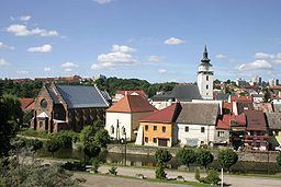
Velké Meziříčí ( [ˈvɛlkɛː ˈmɛzɪr̝iːtʃiː]; German: Groß Meseritsch) is a town in the Vysočina Region, Czech Republic. It is situated under the original Gothic castle in a valley framed by the hills of the Bohemian-Moravian Highlands.
Contents
Map of 594 01 Velk%C3%A9 Mezi%C5%99%C3%AD%C4%8D%C3%AD, Czechia
It is situated on the confluence of the Oslava and Balinka rivers near the Highway D1 with the Vysočina Bridge. The number of the local business subjects is 2095.
History
The first written records of the town come from the 12th century. The settlement obtained full town privileges in 1408 - the celebrations of the 600th anniversary of this event took place in 2008, including the publishing of a representative book; the rights were approved by the king of Bohemia Václav IV. in 1417. The historical centre was designated as conserved zone of sights where the castle (formerly a stronghold from the 12th century, which is very well preserved, and hosts, among other, The Museum of Roads and Highways), the Gothic St. Nicolas Church, an originally Gothic City Hall, the Renaissance Lutheran Grammar School, two Jewish Synagogues and partly preserved city walls with a gate are the most significant buildings. An independent Jewish community had been living in the city since the 17th century – a well-preserved Jewish graveyard with Baroque tombstones comes from the 17th century.
Until 1918, Groß Meseritsch - Velke Meziříčí (German name only before 1867) was part of the Austrian monarchy (Austria side after the compromise of 1867), head of the district with the same name, one of the 34 Bezirkshauptmannschaften in Moravia.