
Surface area 17.7 km (6.8 sq mi) Water volume 337 km (81 cu mi) Surface elevation 189 m Catchment area 141 km² | Max. depth 102 m (335 ft) References NVE Area 17.7 km² Shore length 113.8 km | |
 | ||
Reference Norwegian Water Resources and Energy Directorate | ||
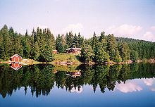
Vegår is a lake in the municipality of Vegårshei in Aust-Agder county, Norway. The lake is located about 3 kilometres (1.9 mi) north of the municipal center of Myra and 12 kilometres (7.5 mi) east of the village of Åmli in the neighboring municipality.
Map of VEG%C3%85R, 4985 Veg%C3%A5rshei, Norway
The three largest parts of the lake are named Vestfjorden, Nordfjorden, and Sørfjorden. The deepest point in the lake is in the Nordfjorden area. There are many small islands in the lake, the largest of which is Furøya.
Vegår supports one of the country's most long-lived and stable beaver populations, as well as a fish fauna consisting of European perch, brown trout, Arctic char, and European eel.
References
Vegår Wikipedia(Text) CC BY-SA