
Max. depth 41 m (135 ft) References NVE Area 36.94 km² Shore length 175.4 km | Surface area 36.94 km (14.26 sq mi) Water volume 0.264 km (0.063 cu mi) Surface elevation 25 m Mean depth 7.4 m | |
 | ||
Reference Norwegian Water Resources and Energy Directorate | ||
Uttern d55 135 mercury verado inn vansj norway april 2009 02
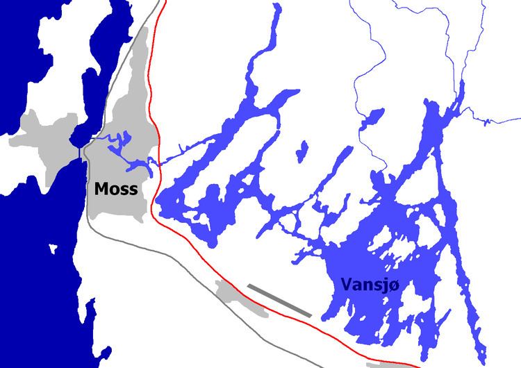
Vansjø is a lake in the municipalities of Moss, Råde, Rygge, Våler in Østfold county, Norway.
Contents
- Uttern d55 135 mercury verado inn vansj norway april 2009 02
- Map of VansjC3B8 Norway
- Uttern d55 135 mercury verado inn vansj norway april 2009 01
- Etymology
- References
Map of Vansj%C3%B8, Norway
Vansjø is part of Moss watershed (Mossevassdraget) stretching from Østmarka. Vansjø has four inflow rivers. The lake is fed by the Hobølelva which drains lake Sværsvann, Veidalselva which originates in Hobøl as well as Svinndalselva and Mørkelva which originate in Våler.
The lake has an area of 36.9 km² and an estimated coastline of about 250 km. Vansjø supplies drinking water in many parts of Moss region.
Uttern d55 135 mercury verado inn vansj norway april 2009 01
Etymology
Etymologically the name likely derives from "Varna sjor", the ancient name of the municipality of Rygge.
References
Vansjø Wikipedia(Text) CC BY-SA