
- left Blomspruit Basin area 7,870 km² | - right Liebenbergstroom - elevation 1,880 m (6,168 ft) - elevation 1,337 m (4,386 ft) | |
 | ||
Woman body recovered after car plunged into vals river
The Vals River (Afrikaans: Valsrivier) is a tributary of the Vaal River in the Free State, South Africa. It is a strong seasonal river.
Contents
- Woman body recovered after car plunged into vals river
- Map of Valsrivier South Africa
- Kroonstad vals river 4 feb 2017
- Course
- Dams in its basin
- References
Map of Valsrivier, South Africa
This river of the Middle Vaal System is a good place for fishing, especially the local Largemouth Yellowfish.
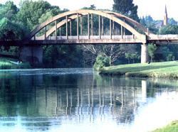
Kroonstad vals river 4 feb 2017
Course
The river source is about 20 km southeast of Paul Roux and about 25 km southeast of Bethlehem. It flows under the N5 road shortly after its source. In its upper course the Vals River flows roughly northwards, bending northwestwards across the highveld towards Lindley and meandering across the plain.
In its middle course there are a number of weirs as it flows mostly through areas of dryland crops and its waters are used for irrigation. The Vals receives a number of small tributaries, the most important of which are the Blomspruit and the Liebenbergstroom. It finally meets the Vaal after crossing the city of Kroonstad.