
- left Vet River - location Near Douglas Discharge 125 m³/s Source Drakensberg | - location Near Breyten - elevation 1,241 m (4,072 ft) Basin area 196,438 km² | |
 | ||
- average 125 m/s (4,414 cu ft/s) Landmarks Vredefort crater, Vaal Dam Basin 196,438 km2 (75,845 sq mi) Cities Johannesburg, Kimberley, Northern Cape Similar Vaal Dam, Drakensberg, Bloemhof Dam, Big Hole, Limpopo River | ||
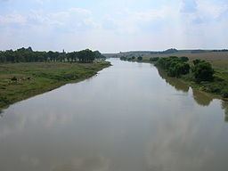
The Vaal River (pronounced /ˈfɑːl/ and alternatively /ˈvɑːl/, especially by English speakers) is the largest tributary of the Orange River in South Africa. The river has its source near Breyten in Mpumalanga province, east of Johannesburg and about 30 kilometres (19 mi) north of Ermelo and only about 240 kilometres (150 mi) from the Indian Ocean. It then flows westwards to its conjunction with the Orange River southwest of Kimberley in the Northern Cape. It is 1,120 kilometres (700 mi) long, and forms the border between Mpumalanga, Gauteng and North West Province on its north bank, and the Free State on its south.
Contents
- Map of Vaal River South Africa
- Vaal river dam wake boarding mash up my happy place
- Tributaries
- Importance to industry and agriculture
- History
- Naming
- Basin ecology
- References
Map of Vaal River, South Africa
Vaal river dam wake boarding mash up my happy place
Tributaries
Some of its tributaries include the Harts River, Vals River, Waterval River, Bamboes Spruit, Blesbokspruit, Mooi River, Vet River, Renoster River, Riet River, Klip River and Wilge River.
Importance to industry and agriculture
Water is drawn from the Vaal to meet the industrial needs of the Greater Johannesburg Metropolitan Area and a large part of the Free State. As a part of the Vaal-Hartz Scheme it is a major source of water for irrigation. Water drawn from the Vaal supports 12 million consumers in Gauteng and surrounding areas.
History
Excavations within the valley of the river have located pebble tools.
Historically, the river formed the northern border of Moshoeshoe I's Basotho kingdom at its height in the mid-19th century, then became the boundary between two Boer republics: The South African Republic (later the Transvaal province) and the Orange Free State. The geographic name "Transvaal" comes from the name of this river, meaning "beyond the Vaal river". This was in respect to the Cape Colony and Natal, which were the main areas of European settlement at the time, and which lay south of the Vaal.
Naming
Vaal is a Dutch name (later Afrikaans), translated by the Griquas or Boers from an earlier Kora Khoikhoi name Tky-Gariep (/hei !garib, drab river). Both Vaal and Tky mean "drab" or "dull", which alludes to the colour of the waters, especially noticeable during flood season when the river carries a lot of silt. In the upper reaches the river was named Likwa (Sindebele), Ikwa (isiZulu), ilikwa (siSwati), lekwa (Sesotho), or cuoa by the Khoikhoi, all referring to the plain it traverses.
Basin ecology
According to Hogan the headwaters portion of the basin supports high endemism in reptiles, and lower in the watershed are elevated levels of endemism for small mammals.