Country United States ZIP codes 78801-78802 Elevation 277 m Local time Monday 5:45 AM | Time zone Central (CST) (UTC-6) Area code(s) 830 Population 16,284 (2013) | |
 | ||
Weather 9°C, Wind NE at 0 km/h, 99% Humidity University | ||
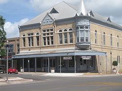
Uvalde (/juˈvældi/ yoo-VAL-dee) is a city in and the county seat of Uvalde County, Texas, United States. The population was 15,751 at the 2010 census.
Contents
- Map of Uvalde TX 78801 USA
- Geography
- Climate
- Demographics
- Education
- Cultural attractions
- Religion
- Transportation
- Notable people
- Media
- References
Map of Uvalde, TX 78801, USA
Uvalde was founded by Reading Wood Black in 1853 as the town of Encina. In 1856, when the county was organized, the town was renamed Uvalde after Spanish governor Juan de Ugalde (Cádiz, Andalucía, 1729-1816) and was chosen as county seat. It is usually considered the southern limit of the Texas Hill Country or the most northerly part of South Texas. Historically, Uvalde is known as the Honey Capital of the World for production of huajillo (also spelled guajillo) honey, a mild, light-colored honey, dating back to the 1870s.
Uvalde was the home of John Nance "Cactus Jack" Garner, former Speaker of the House and Vice President of the United States. Oscar-winning actor Matthew McConaughey, actress Dale Evans, and former Governor of Texas Dolph Briscoe (after whom the post office is named), were born in Uvalde. The city is also home to the Grammy Award-winning Tejano/Norteño group Los Palominos.
Geography
Uvalde is located at 29°12′52″N 99°47′23″W (29.214313, -99.789644) at the crossroads of U.S Hwy 90 and U.S. Hwy 83.
According to the United States Census Bureau, the city has a total area of 7.6 square miles (19.8 km2), all of it land.
Uvalde is known as one of the best locations for soaring in the United States. It is the site of the 1991 and 2012 World Gliding Championships.
Climate
The climate in this area is characterized by hot, humid summers and generally mild to cool winters. According to the Köppen Climate Classification system, Uvalde has a humid subtropical climate, Cfa, on climate maps.
Demographics
At the 2010 census, the population was 15,751 people
At the 2000 census, there were 14,929 people, 4,796 households and 3,716 families residing in the city. The population density was 2,220.2 per square mile (857.8/km²). There were 5,313 housing units at an average density of 790.1 per square mile (305.3/km²). The racial makeup of the city was 73.27% White, 0.47% African American, 0.62% Native American, 0.48% Asian, 0.07% Pacific Islander, 22.12% from other races, and 2.97% from two or more races. Hispanic or Latino (of any race) were 75.48% of the population.
There were 4,796 households of which 41.8% had children under the age of 18 living with them, 55.6% were married couples living together, 16.9% had a female householder with no husband present, and 22.5% were non-families. 20.1% of all households were made up of individuals and 10.4% had someone living alone who was 65 years of age or older. The average household size was 3.02 and the average family size was 3.50.
32.4% of the population were under the age of 18, 9.6% from 18 to 24, 25.7% from 25 to 44, 18.3% from 45 to 64, and 14.0% who were 65 years of age or older. The median age was 31 years. For every 100 females there were 90.3 males. For every 100 females age 18 and over, there were 85.5 males.
The median household income was $25,259 and the median family income was $27,897. Males had a median income of $25,600 compared with $15,674 for females. The per capita income for the city was $11,735. About 24.2% of families and 29.0% of the population were below the poverty line, including 40.1% of those under age 18 and 23.8% of those age 65 or over.
Education
The city is served by the Uvalde Consolidated Independent School District which serves Uvalde, Real and Zavala counties. The school district has ten schools.
Southwest Texas Junior College has a campus near Uvalde, next to Garner Field.
Cultural attractions
Also located in Uvalde:
Religion
Transportation
Uvalde, along with San Antonio, Carrizo Springs, Crystal City, and Corpus Christi, was a major stop on the defunct San Antonio, Uvalde and Gulf Railroad, which operated from 1909 until it was merged into the Missouri Pacific Railroad in 1956. From 1909 to 1912, the SAU&G was known as the Crystal City and Uvalde Railroad. The San Antonio-to-Corpus Christi freight route is now within the Union Pacific system.
The City of Uvalde owns Garner Field, a general aviation airport east of Uvalde.
