
Length 35.74 km | ||
 | ||
South end: SR 389 in Hildale/Colorado City, AZ | ||
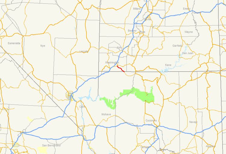
State Route 59 (SR-59) is a state highway in the U.S. state of Utah. The highway connects Hurricane to the twin cities of Hildale and Colorado City, Arizona. The highway connects to US-89A through Arizona State Route 389. The route was added to the state highway system in 1914, and has had several designations.
Contents
Map of UT-59, Utah, USA
Route description
The route begins at the Arizona border in Hildale (whose Arizona counterpart is Colorado City). These two towns are largely known for the Fundamentalist Church of Jesus Christ of Latter-day Saints (or the FLDS), a Mormon fundamentalist sect that broke away the mainstream Church of Jesus Christ of Latter-day Saints (or the LDS). The highway proceeds northwest past Hildale (where the street is known as State Street) for nearly 15 miles before beginning a 5-mile (8 km) descent into Hurricane. A truck escape ramp is located along this descent. The route enters Hurricane on 100 South and proceeds to turn north on Main Street. The route proceeds for a block before terminating at SR-9 (State Street).
History
The road from SR-15 (now SR-9 and SR-17) at La Verkin Junction south to Hurricane was added to the state highway system in 1912, and in 1914 it was extended southeast via Big Plain Junction to Arizona. In the 1920s, the entire route was numbered State Route 16. A connection from SR-15 (now SR-9) in Rockville south to SR-16 at Big Plain Junction became a state highway in 1925. In 1927, SR-16 was moved to the Rockville-Arizona route, and the roadway between La Verkin and Big Plain Junctions became part of the new SR-17, which also went southwest from Hurricane to SR-1 (US-91, now I-15). The Hurricane-Big Plain Junction branch was split from SR-17 in 1931, becoming a new State Route 59. The entirety of SR-16 was deleted in 1935, permanently removing the Rockville-Big Plain Junction road from the state highway system; the highway beyond Big Plain Junction to Arizona was also removed, but was re-added in 1941 as part of SR-59, forming the present extent of that route. SR-59 was almost completed relocated in 1962, including a new crossing of the state line; it had ended at the west end of Uzona Avenue, which extends west along the border from Colorado City/Hildale, but now crosses within the city limits. The connecting State Route 389 in Arizona was not added to that state's state highway system until 1959.
Major intersections
The entire route is in Washington County.