
41 SR-42 → | Length 70.19 km | |
 | ||
Existed: 1925 as a state highway; 1927 as SR-28 – present | ||
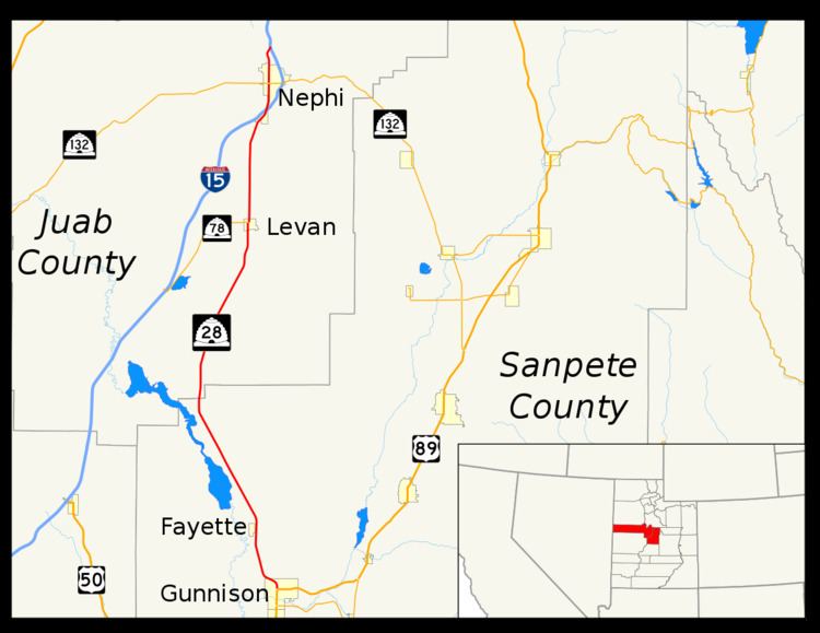
State Route 28 (SR-28) is a state highway in central Utah running for 43.612 miles (70.187 km) in Sanpete and Juab counties from Gunnison to Nephi. It serves as a connection from the Wasatch Front to the Sevier Valley.
Contents
Map of UT-28, Utah, USA
Route description
SR-28 begins at an intersection with US-89 in central Gunnison and heads north and northwest to Fayette. It continues northwest past the Sevier Bridge Reservoir and northeast past the Skinner Peaks and Horse Heaven Mountain to Levan.
SR-28 then continues north through Levan to Nephi, where it intersects I-15 at the south end of town and continues north along the I-15 Business Loop through Nephi, ending at an intersection with I-15 north of town.
History
The Utah State Legislature added the road from US-89 in Gunnison north to US-91 (now SR-78) in Levan to the state highway system in 1925 and numbered it SR-28 in 1927. In 1968, the legislature designated several portions of soon-to-be truncated US-91 with several other numbers: SR-163 (renumbered SR-78 in the 1977 renumbering) from the split west of Levan east to that town, an extension of SR-28 from Levan to a proposed interchange with I-15 two miles (3.2 km) south of Sheep Lane, and State Route 41 from another interchange one-half mile (0.8 km) south of Sheep Lane through Nephi to the north end of the bypass. The approximately 1.5 miles (2.4 km) piece of old US-91 between the two interchanges would become a local road. The state legislature extended SR-41 north along old US-91 through Mona in 1969, taking it to a proposed interchange near Rocky Ridge Road, and in 1971 the State Road Commission agreed that, once the bypass of Mona was complete, SR-41 would be truncated back to its 1968 terminus, with a short connection between Mona and I-15 at exit 233 becoming SR-54. The legislature and commission carried out this change in 1975, with SR-41 now running north to a temporary connection with I-15 about one mile (1.5 km) north of Country Road. (When I-15 was built, it was truncated slightly to exit 228 near Country Road.)
When I-15 was eventually built around Levan and Nephi in the 1980s, it did not follow the originally planned alignment, but was farther west in the Levan area, and crossed old US-91 between the two communities, bypassing Nephi to the east instead of to the west. Since only one interchange was constructed south of Nephi, all of old US-91 remained a state highway there, and the north end of SR-28 and south end of SR-41 were in the same place. This was changed in 2006, when SR-28 was extended north to absorb all of SR-41.