
Length 197.7 km | ||
 | ||
Touristroutes: Utah's Scenic Byway 12 - A Journey Through Time | ||
State Route 12 or Scenic Byway 12 (SR-12), also known as "Highway 12 — A Journey Through Time Scenic Byway", is a state highway designated an All-American Road located in Garfield County and Wayne County, Utah, United States.
Contents
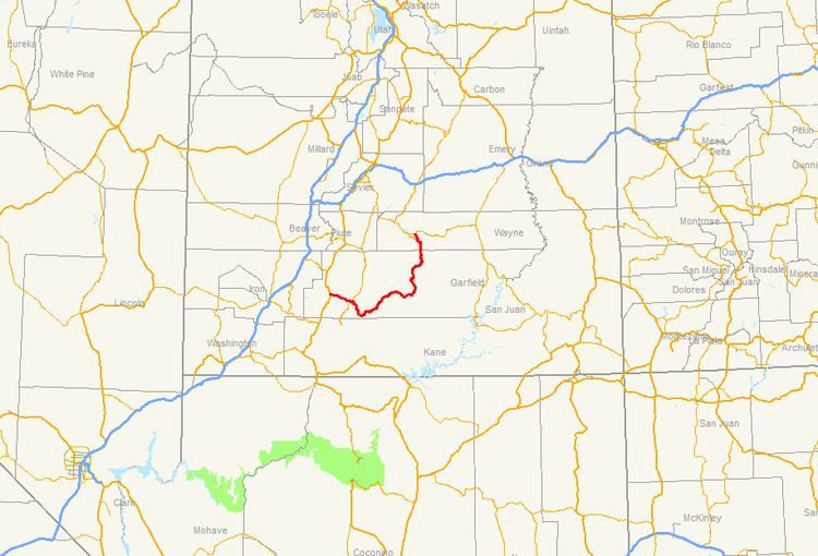
Map of UT-12, Utah, USA
Route description
Proceeding west to east for 122 miles (nearly 200 km), the highway starts south of Panguitch at an intersection with US-89, crosses part of Dixie National Forest and Bryce Canyon National Park, continues through the small towns of Tropic, Cannonville, and Henrieville. It crosses various parts of Grand Staircase-Escalante National Monument (GS-ENM), continues northeast through Escalante and over the Escalante River, then north through more of GS-ENM, Boulder, the Aquarius Plateau, Grover, ending in Torrey at an intersection with SR-24, five miles (8 km) west of Capitol Reef National Park. The 30-mile (48 km) long portion of the highway that ascends and descends Boulder Mountain on the Aquarius Plateau is known as Boulder Mountain Highway.
Traffic volume
The Average Daily Traffic (AADT) on SR-12 is at its greatest at its western junction with US-89, where the count for 2005 was 2,430. At its other end, at the junction with SR-24, the traffic bottoms out at 435.
History
The road from Bryce Canyon Junction to Tropic was added to the state highway system in 1914, and in 1923 a branch from Tropic Junction to Bryce Canyon was built as a forest road. The State Road Commission numbered the route to Bryce Canyon SR-12 in the 1920s, and in 1927 the state legislature assigned it to both branches, to Bryce Canyon and Tropic, but split off the branch to Tropic as State Route 54 in 1931. That same year, a new State Route 120 was created, continuing the road from Tropic to Henrieville, and in 1935 it became part of SR-54. Another road was also added to the state highway system in 1914, connecting SR-22 at Widtsoe with Escalante, and it was numbered State Route 23 in 1927. An extension took SR-23 northeast to Boulder in 1941, and in 1947 SR-54 absorbed SR-23, with the Widtsoe-Escalante road dropped in favor of Henrieville-Escalante. State Route 117, running southeast from SR-24 near Teasdale to Grover, became a state highway in 1931, and was extended south to Boulder in 1957, becoming part of SR-54 in 1966. In 1969, SR-54 became part of SR-12, but most of former SR-117 was dropped, leaving SR-12 to stretch from Bryce Canyon Junction to the north limit of Boulder (at the Dixie National Forest boundary), with a short spur to Bryce Canyon. This spur became a new SR-63 in 1975, and in 1985 the route was extended back north from Boulder to SR-24, using a different route than old SR-117 north of Grover.