
Established 1369 Time zone EET (UTC+2) Area 155 ha | Elevation/(average value of) 499 m (1,637 ft) Postal code 82612 Local time Monday 6:47 AM | |
 | ||
Weather 6°C, Wind SW at 6 km/h, 71% Humidity | ||
Urych (Ukrainian: У́рич, Polish: Urycz) is a village (selo) in Skole Raion, Lviv Oblast, of Western Ukraine. Local government — Pidhorodetska village council.
Contents
Map of Urych, Lvivska, Ukraine
Geography
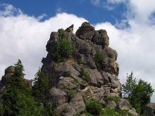
It is a village located in the valley of the ridges of rock groups. The rocks located in the middle of the remnants of a massive and stone eroded Paleocene (55 million absolute age.). These of the rock are ancient Rus Rock defense the cliff-side fortress complex of Tustan’.
This village is located on the altitude of 499 metres (1,640 ft) above sea level, and is located at a distance 118 kilometres (73 mi) from the regional center of Lviv, 40 kilometres (25 mi) from the district center Skole, and 8 kilometres (5.0 mi) from the urban village Skhidnytsia.
History
The village was founded in 1369 and is located south of the famous resort Skhidnytsia. 1920-1939 situated in Stanisławów Voivodeship. Wehrmacht soldiers burned here about 100 Polish soldiers in September 1939.
Attractions
In the village there is one architectural monument of local importance of Skole district–- Church of Sts. Nicholas (wood) 19th century (2378-М), operates a museum history of Ruthenian Tustan fortress.