
- right Ch'illkamayu Source Khunurana | Length 724 km | |
 | ||
- left Luq'umayu, Kusichaka River, Kachimayu | ||
Machu picchu urubamba river sacred valley adventures by disney peru
The Urubamba River or Vilcamayo River (possibly from Quechua Willkamayu, for "sacred river") is a river in Peru. Upstream it is called Vilcanota River (possibly from Aymara Willkanuta, for "house of the sun"). Within the La Convención Province the naming changes to Urubamba. A partially navigable headwater of the Amazon River, it rises in the Andes to the southeast of Cuzco. It originates on the slopes of Khunurana in the Puno Region, Melgar Province, near the La Raya pass. It flows north-north-west for 724 kilometers before coalescing with the Tambo River to form the Ucayali River.
Contents
- Machu picchu urubamba river sacred valley adventures by disney peru
- Map of Urubamba River Peru
- Whitewater rafting urubamba river
- Upper UrubambaEdit
- Lower UrubambaEdit
- References
Map of Urubamba River, Peru
John Walter Gregory, the British geologist, drowned in the river on June 2, 1932 while on a geological expedition to the Andes.
The Urubamba is divided into Upper Urubamba and Lower Urubamba, the dividing feature being the Pongo de Mainique, an infamous whitewater canyon.
Whitewater rafting urubamba river
Upper UrubambaEdit
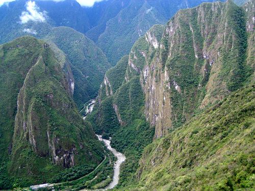
The Upper Urubamba (Alto Urubamba) valley features a high population and extensive irrigation works. A number of ruins of the Inca Empire lie in the Sacred Valley, including the Incan city of Machu Picchu, Patallaqta, Pikillaqta and Raqch'i.
Lower UrubambaEdit
The Lower Urubamba (Bajo Urubamba) is relatively undeveloped and features a significant indigenous population consisting of the Campa tribes, principally the Machiguenga (Matsigenka) and Ashaninka. The economy is based on forestry and the nearby Camisea Gas Project. The main settlement in the region is the town of Sepahua.
The lower Urubamba River was mapped for the first time in 1934 by Edward Kellog Strong III. He and two friends from Palo Alto, California, Art Post and Gain Allan John, navigated the river with its ferocious rapids by canoe and balsa rafts provided by the indigenous people. The mapping was done at the request of the Peruvian military when they heard of the expedition planned by the three 18-year-olds.
It was turned over to the military when the boys arrived in Iquitos. It was the only map of the river until it was mapped by satellite many years later. The names and places on the latest map came from the original map drawn by Edward Strong.