
OS grid NZ594015 Elevation 454 m Listing Marilyn | Topo map OS Landranger 93 Prominence 409 m | |
 | ||
Similar Gisborough Moor, Hasty Bank, Burnhope Seat, Sighty Crag, Grayrigg Forest | ||
Urra Moor is the highest moor in the North York Moors at 454 metres (1,454 ft) above sea level, in the national park in North Yorkshire, England. The name applies to the moor as a whole; the summit itself is known as Round Hill.
Map of Urra Moor, Middlesbrough, UK
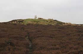
The summit is crowned by a trig point, and a track passes about 100 metres (110 yd) to the south of this point. This track forms part of the route of both the Lyke Wake Walk and the Cleveland Way, and also forms the most commonly used route of ascent for Urra Moor. It is only 3 kilometres (1.9 mi) from the car park at Clay Bank to the summit via this route; total ascent is just under 200 metres (660 ft).
Urra Moor is noted for its prehistoric remains. There are a number of barrows, and several carved rocks, including some cup and ring carvings. Probably the most striking relic is the Face Stone, a carved stone about 1 metre (3 ft 3 in) in height into which has been carved the shape of a face.