
Max. width 610 m (2,000 ft) Shore length 5.486 km | Primary outflows Rock Creek Max. length 2,134 m (7,001 ft) Surface elevation 2,492 m | |
 | ||
Location Duchesne County, Utah,United States | ||
Fly fishing upper stillwater reservoir
Upper Stillwater Reservoir is a large high mountain reservoir on the south slope of the High Uintas in Duchesne County, Utah. The reservoir is part of the Central Utah Project.
Contents
- Fly fishing upper stillwater reservoir
- Map of Upper Stillwater Reservoir Utah USA
- RecreationEdit
- Annual SpillEdit
- References
Map of Upper Stillwater Reservoir, Utah, USA
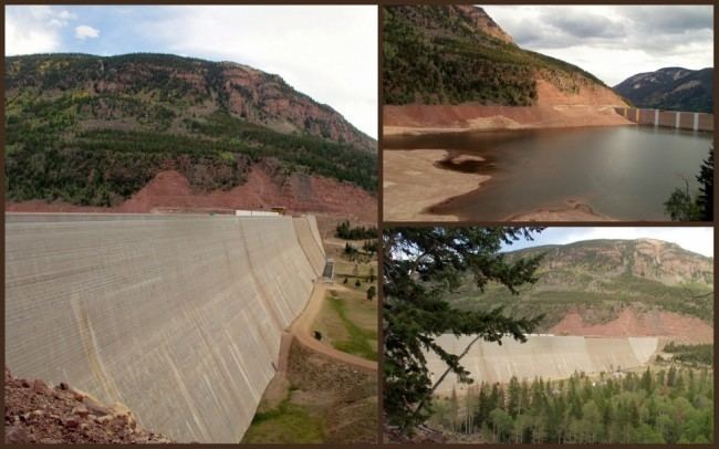
The reservoir was created in 1987 by the construction of a concrete gravity dam (Upper Stillwater Dam). The architecture of the rolled concrete dam is an attraction for engineers.
The reservoir elevation is 8,176 ft, and the mean depth is 103.5 ft. Available fish species include rainbow, brown, and brook trout.
The watershed is primarily the Uinta Mountains, the watershed high point being Ostler Peak (12,717 ft). It is estimated that twice or more the capacity of the reservoir is diverted towards the Wasatch Front annually. The primary use of the water is for irrigation.
RecreationEdit
The area has one main campground, Rock Creek. The reservoir serves as a popular trailhead into the High Uintas Wilderness Area with the boundary only one mile north of the dam near the high water line for the reservoir. Recreation management is under the jurisdiction of the U.S. Forest Service, Ashley National Forest. The managed recreation season is from June through September with high use on holidays and weekends. Boating, swimming, camping, fishing, hiking, horseback riding, picnicking, recreational vehicle driving, wildlife viewing, and winter sports are all popular activities.
Annual SpillEdit
The Stillwater Dam is designed with a steep stepped spillway. During years of high snow or fast melt conditions, the dam may fill until the water elevation reaches the spillway. The spill creates a curtain of falling water 600 feet wide and 200 feet tall. The event typically lasts for a few days and commonly attracts tourist and media attention.