
Total height 114 feet (35 m) Elevation 1,707 m | Type Block Height 35 m Watercourse Henrys Fork | |
 | ||
Similar Lower Mesa Falls, Henrys Fork, Harriman State Park, Mesa Falls Scenic Byway, Rocky Mountains | ||
Let s visit 2015 fall discovering upper mesa falls idaho
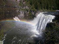
Upper Mesa Falls is a waterfall on the Henrys Fork in the Caribou-Targhee National Forest. Upstream from Lower Mesa Falls, it is roughly 16 miles (26 km) away from Ashton, Idaho.
Contents
- Let s visit 2015 fall discovering upper mesa falls idaho
- Map of Upper Mesa Falls Idaho USA
- Upper mesa falls idaho
- Formation
- References
Map of Upper Mesa Falls, Idaho, USA
Upper Mesa Falls is roughly 114 feet (35 m) high and 200 feet (61 m) wide.
Upper mesa falls idaho
Formation
Mesa Falls Tuff, which is the rock over which Upper Mesa Falls cascades, was formed 1.3 million years ago. A cycle of rhyolitic volcanism from the Henrys Fork caldera deposited a thick layer of rock and ash across the area. This layer compressed and hardened over time.
Between 200,000 and 600,000 years ago, the river eroded a wide canyon which was subsequently partly filled with basalt lava flows. The Henrys Fork of the Snake River then carved the channel through the basalt; which is the inner canyon seen today.